Voisins-le-Bretonneux elevation
Voisins-le-Bretonneux (Île-de-France, Yvelines), France elevation is 164 meters and Voisins-le-Bretonneux elevation in feet is 538 ft above sea level [src 1]. Voisins-le-Bretonneux is a populated place (feature code) with elevation that is 10 meters (33 ft) smaller than average city elevation in France.
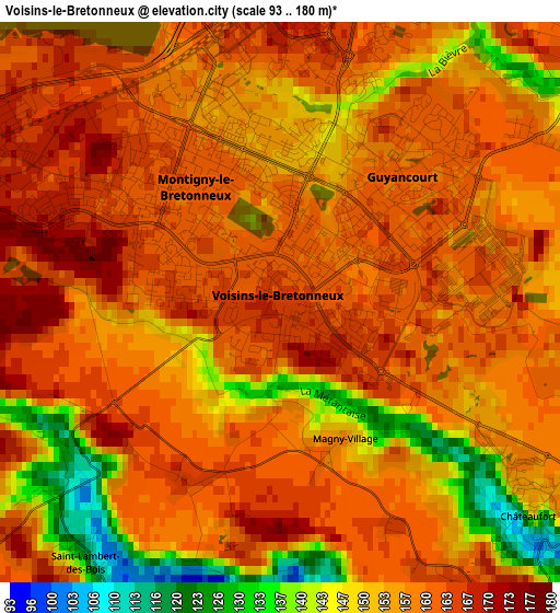
Below is the Elevation map of Voisins-le-Bretonneux, which displays elevation range with different colors. Scale of the first map is from 93 to 180 m (305 to 591 ft) with average elevation of 156.6 meters (=514 ft) [note 1]
These maps also provides idea of topography and contour of this city, they are displayed at different zoom levels. More info about maps, scale and edge coordinates you can find below images.
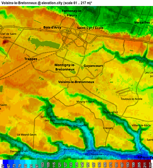
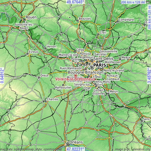
| \ | Map #1 | Map #2 | Topo.Map |
| Scale [m] | 93..180 m | 61..217 m | × |
| Scale [ft] | 305..591 ft | 200..712 ft | × |
| Average | 156.6 m = 514 ft | 150 m = 492 ft | × |
| Width | 6.44 km = 4 mi | 12.88 km = 8 mi | 206.2 km = 128.1 mi |
| Height | 6.44 km = 4 mi | 12.88 km = 8 mi | 206.1 km = 128.1 mi |
| ↑Max Latitude | 48.786892° | 48.815838° | 49.67645° |
| Latitude at center | 48.75793° | 48.75793° | 48.75793° |
| ↓Min Latitude | 48.728951° | 48.699955° | 47.82231° |
| ← Min Longitude | 2.007425° | 1.963479° | 0.64512° |
| Longitude center | 2.05137° | 2.05137° | 2.05137° |
| →Max Longitude | 2.095315° | 2.139261° | 3.45762° |
Nearby cities:
Cities around Voisins-le-Bretonneux sort by population:
• Saint-Quentin-en-Yvelines elevation 166 m
2.8 km,  303°
303°
• Montigny-le-Bretonneux 162 m
1.6 km,  306°
306°
• Guyancourt 161 m
2.4 km,  43°
43°
• Trappes 173 m
3 km, 306°
• Saint-Cyr-l’École 153 m
4.7 km,  15°
15°
• Bois-d’Arcy 167 m
5.1 km,  336°
336°
• Magny-les-Hameaux 154 m
1.8 km,  155°
155°
• Saint-Rémy-lès-Chevreuse 84 m
6 km, 161°
• Buc 122 m
5.8 km,  69°
69°
• Chevreuse 92 m
5.9 km,  193°
193°
• Châteaufort 153 m
3.8 km,  130°
130°
• Villiers-le-Bâcle 150 m
6 km,  123°
123°
Multilingual:
 En español:
Voisins-le-Bretonneux elevación 164 m.
 En France:
Voisins-le-Bretonneux élévation 164 m.
 Auf Deutsch:
Voisins-le-Bretonneux höhe über dem Meeresspiegel ist 164 m.
 На русском:
Voisins-le-Bretonneux высота над уровнем моря 164 м
Sources and notes:
- [note 1] Map square and city borders are not equal. Map elevation data is calculated only from area inside that square.
- [src 1] Elevation data from geonames database provided with same terms of usage.
- [src 2] The elevation map of Voisins-le-Bretonneux is generated using elevation data from NASA's 3 arcsec (90m) resolution SRTM data.
- [src 3] Base (background) map © OpenStreetMap contributors tiles are generated by Geofabrik and OpenTopoMap.
Copyright & License:
This Voisins-le-Bretonneux Elevation Map is licensed under CC BY-SA. You may reuse any part from this page, if you give a proper credit by linking to this URL:
 More info on terms of use page.