Villiers-le-Bâcle elevation
Villiers-le-Bâcle (Île-de-France, Département de l'Essonne), France elevation is 150 meters and Villiers-le-Bâcle elevation in feet is 492 ft above sea level [src 1]. Villiers-le-Bâcle is a populated place (feature code) with elevation that is 24 meters (79 ft) smaller than average city elevation in France.
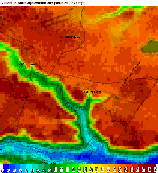
Below is the Elevation map of Villiers-le-Bâcle, which displays elevation range with different colors. Scale of the first map is from 59 to 176 m (194 to 577 ft) with average elevation of 141 meters (=463 ft) [note 1]
These maps also provides idea of topography and contour of this city, they are displayed at different zoom levels. More info about maps, scale and edge coordinates you can find below images.
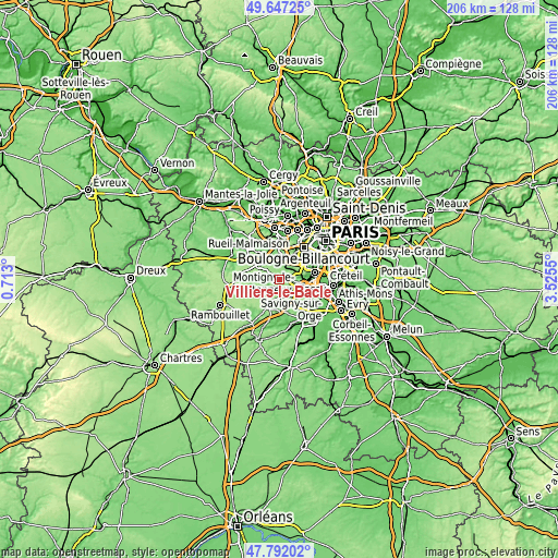
| \ | Map #1 | Topo.Map |
| Scale [m] | 59..176 m | × |
| Scale [ft] | 194..577 ft | × |
| Average | 141 m = 463 ft | × |
| Width | 6.45 km = 4 mi | 206.3 km = 128.2 mi |
| Height | 6.45 km = 4 mi | 206.3 km = 128.2 mi |
| ↑Max Latitude | 48.757169° | 49.64725° |
| Latitude at center | 48.72819° | 48.72819° |
| ↓Min Latitude | 48.699194° | 47.79202° |
| ← Min Longitude | 2.075305° | 0.713° |
| Longitude center | 2.11925° | 2.11925° |
| →Max Longitude | 2.163195° | 3.5255° |
Nearby cities:
Cities around Villiers-le-Bâcle sort by population:
• Guyancourt elevation 161 m
6 km,  326°
326°
• Gif-sur-Yvette 147 m
5.1 km,  168°
168°
• Voisins-le-Bretonneux 164 m
6 km,  303°
303°
• Bures-sur-Yvette 62 m
4.9 km,  129°
129°
• Magny-les-Hameaux 154 m
4.6 km,  291°
291°
• Jouy-en-Josas 147 m
5 km,  47°
47°
• Saint-Rémy-lès-Chevreuse 84 m
3.9 km,  232°
232°
• Buc 122 m
5.4 km,  5°
5°
• Saclay 155 m
3.7 km,  82°
82°
• Gometz-le-Châtel 146 m
5.7 km, 166°
• Châteaufort 153 m
2.3 km, 291°
• Les Loges-en-Josas 148 m
4.2 km,  21°
21°
Multilingual:
 En español:
Villiers-le-Bâcle elevación 150 m.
 En France:
Villiers-le-Bâcle élévation 150 m.
 Auf Deutsch:
Villiers-le-Bâcle höhe über dem Meeresspiegel ist 150 m.

Sources and notes:
- [note 1] Map square and city borders are not equal. Map elevation data is calculated only from area inside that square.
- [src 1] Elevation data from geonames database provided with same terms of usage.
- [src 2] The elevation map of Villiers-le-Bâcle is generated using elevation data from NASA's 3 arcsec (90m) resolution SRTM data.
- [src 3] Base (background) map © OpenStreetMap contributors tiles are generated by Geofabrik and OpenTopoMap.
Copyright & License:
This Villiers-le-Bâcle Elevation Map is licensed under CC BY-SA. You may reuse any part from this page, if you give a proper credit by linking to this URL:
 More info on terms of use page.