Goba elevation
Goba (Oromiya), Ethiopia elevation is 2682 meters and Goba elevation in feet is 8799 ft above sea level [src 1]. Goba is a populated place (feature code) with elevation that is 786 meters (2579 ft) bigger than average city elevation in Ethiopia.
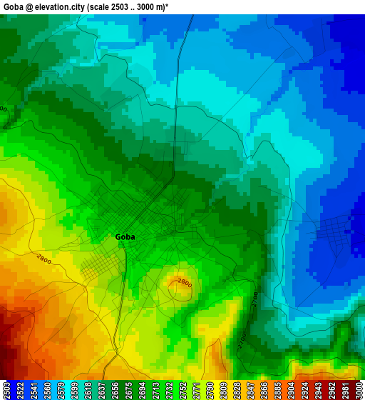
Below is the Elevation map of Goba, which displays elevation range with different colors. Scale of the first map is from 2503 to 3000 m (8212 to 9843 ft) with average elevation of 2670.6 meters (=8762 ft) [note 1]
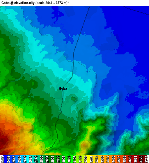
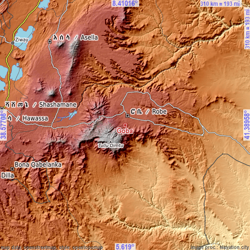
These maps also provides idea of topography and contour of this city, they are displayed at different zoom levels. More info about maps, scale and edge coordinates you can find below images.
| \ | Map #1 | Map #2 | Topo.Map |
| Scale [m] | 2503..3000 m | 2441..3773 m | × |
| Scale [ft] | 8212..9843 ft | 8009..12379 ft | × |
| Average | 2670.6 m = 8762 ft | 2730.8 m = 8959 ft | × |
| Width | 9.7 km = 6 mi | 19.4 km = 12.1 mi | 310.3 km = 192.8 mi |
| Height | 9.7 km = 6 mi | 19.4 km = 12.1 mi | 310.4 km = 192.9 mi |
| ↑Max Latitude | 7.060284° | 7.103894° | 8.41016° |
| Latitude at center | 7.01667° | 7.01667° | 7.01667° |
| ↓Min Latitude | 6.973052° | 6.929429° | 5.619° |
| ← Min Longitude | 39.939385° | 39.895439° | 38.57708° |
| Longitude center | 39.98333° | 39.98333° | 39.98333° |
| →Max Longitude | 40.027275° | 40.071221° | 41.38958° |
Nearby cities:
Cities around Goba sort by population:
• Hawassa elevation 1697 m
166.4 km,  271°
271°
• Shashemenē 1924 m
154 km,  277°
277°
• Ziway 1649 m
172.9 km,  306°
306°
• Kibre Mengist 1690 m
167.6 km,  221°
221°
• Āsasa 2369 m
86.9 km, 276°
• Dodola 2464 m
88.4 km, 267°
• Ginir 1945 m
81.4 km,  80°
80°
• Huruta 2030 m
144.1 km,  331°
331°
• Leku 1873 m
170.6 km,  264°
264°
• Sirre 1755 m
154.7 km,  339°
339°
• Kofelē 2666 m
132.5 km, 272°
• Hāgere Selam 2746 m
172.5 km,  249°
249°
Multilingual:
 En español:
Goba elevación 2682 m.
 En France:
Goba élévation 2682 m.


Sources and notes:
- [note 1] Map square and city borders are not equal. Map elevation data is calculated only from area inside that square.
- [src 1] Elevation data from geonames database provided with same terms of usage.
- [src 2] The elevation map of Goba is generated using elevation data from NASA's 3 arcsec (90m) resolution SRTM data.
- [src 3] Base (background) map © OpenStreetMap contributors tiles are generated by Geofabrik and OpenTopoMap.
Copyright & License:
This Goba Elevation Map is licensed under CC BY-SA. You may reuse any part from this page, if you give a proper credit by linking to this URL:
 More info on terms of use page.