Hawassa elevation
Hawassa (SNNPR), Ethiopia elevation is 1697 meters and Hawassa elevation in feet is 5568 ft above sea level [src 1]. Hawassa is a seat of a first-order administrative division (feature code) with elevation that is 199 meters (653 ft) smaller than average city elevation in Ethiopia.
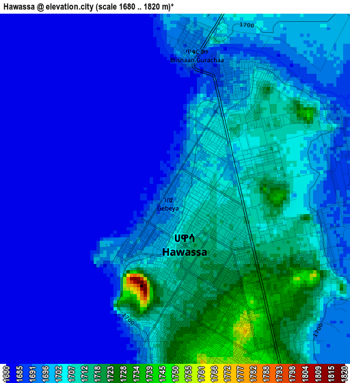
Below is the Elevation map of Hawassa, which displays elevation range with different colors. Scale of the first map is from 1680 to 1820 m (5512 to 5971 ft) with average elevation of 1698 meters (=5571 ft) [note 1]
These maps also provides idea of topography and contour of this city, they are displayed at different zoom levels. More info about maps, scale and edge coordinates you can find below images.
| \ | Map #1 | Map #2 | Topo.Map |
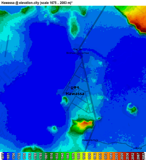
| Scale [m] | 1680..1820 m | 1675..2083 m | × |
| Scale [ft] | 5512..5971 ft | 5495..6834 ft | × |
| Average | 1698 m = 5571 ft | 1712 m = 5617 ft | × |
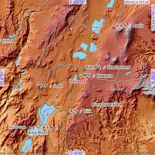
| Width | 9.7 km = 6 mi | 19.4 km = 12.1 mi | 310.3 km = 192.8 mi |
| Height | 9.7 km = 6 mi | 19.4 km = 12.1 mi | 310.3 km = 192.8 mi |
| ↑Max Latitude | 7.10566° | 7.149266° | 8.45539° |
| Latitude at center | 7.06205° | 7.06205° | 7.06205° |
| ↓Min Latitude | 7.018436° | 6.974818° | 5.6645° |
| ← Min Longitude | 38.432405° | 38.388459° | 37.0701° |
| Longitude center | 38.47635° | 38.47635° | 38.47635° |
| →Max Longitude | 38.520295° | 38.564241° | 39.8826° |
Nearby cities:
Cities around Hawassa sort by population:
• Sodo elevation 2045 m
82 km,  254°
254°
• Shashemenē 1924 m
20.5 km,  41°
41°
• Dīla 1594 m
73.9 km,  193°
193°
• Yirga ‘Alem 1778 m
35.3 km, 190°
• Bodītī 1998 m
68.1 km,  261°
261°
• K’olīto 1781 m
51.8 km,  303°
303°
• Āsasa 2369 m
80 km,  86°
86°
• Dodola 2464 m
78.5 km,  96°
96°
• Wendo 1911 m
51.8 km, 187°
• Leku 1873 m
21.3 km, 189°
• Kofelē 2666 m
33.9 km, 89°
• Hāgere Selam 2746 m
64.5 km,  176°
176°
Multilingual:
 En español:
Hawassa elevación 1697 m.
 En France:
Hawassa élévation 1697 m.


Sources and notes:
- [note 1] Map square and city borders are not equal. Map elevation data is calculated only from area inside that square.
- [src 1] Elevation data from geonames database provided with same terms of usage.
- [src 2] The elevation map of Hawassa is generated using elevation data from NASA's 3 arcsec (90m) resolution SRTM data.
- [src 3] Base (background) map © OpenStreetMap contributors tiles are generated by Geofabrik and OpenTopoMap.
Copyright & License:
This Hawassa Elevation Map is licensed under CC BY-SA. You may reuse any part from this page, if you give a proper credit by linking to this URL:
 More info on terms of use page.