Kofelē elevation
Kofelē (Oromiya), Ethiopia elevation is 2666 meters and Kofelē elevation in feet is 8747 ft above sea level [src 1]. Kofelē is a populated place (feature code) with elevation that is 770 meters (2526 ft) bigger than average city elevation in Ethiopia.
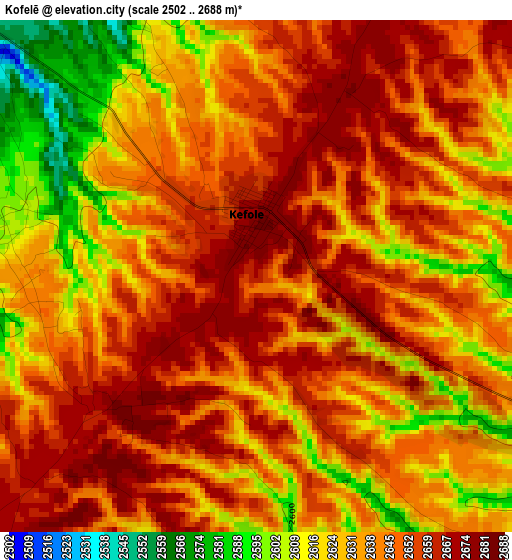
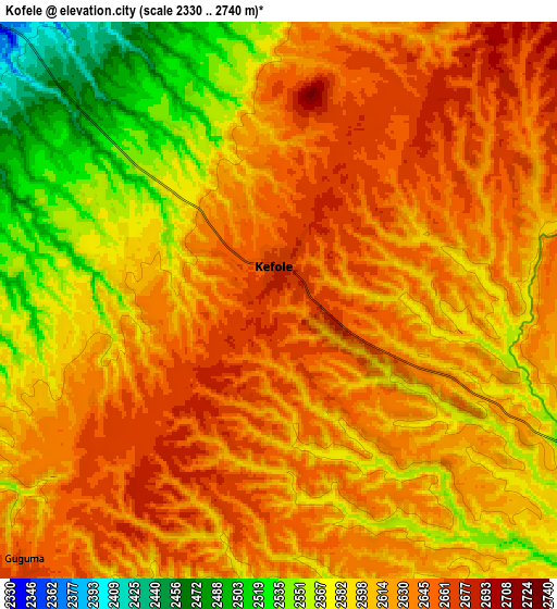
Below is the Elevation map of Kofelē, which displays elevation range with different colors. Scale of the first map is from 2502 to 2688 m (8209 to 8819 ft) with average elevation of 2639.8 meters (=8661 ft) [note 1]
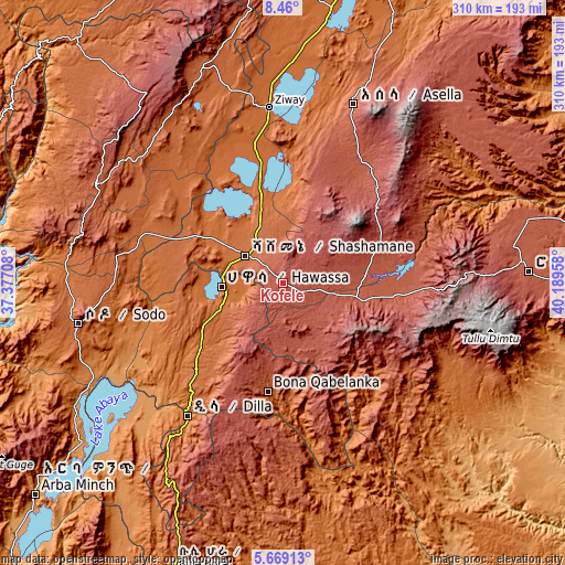
These maps also provides idea of topography and contour of this city, they are displayed at different zoom levels. More info about maps, scale and edge coordinates you can find below images.
| \ | Map #1 | Map #2 | Topo.Map |
| Scale [m] | 2502..2688 m | 2330..2740 m | × |
| Scale [ft] | 8209..8819 ft | 7644..8990 ft | × |
| Average | 2639.8 m = 8661 ft | 2610.4 m = 8564 ft | × |
| Width | 9.7 km = 6 mi | 19.4 km = 12.1 mi | 310.3 km = 192.8 mi |
| Height | 9.7 km = 6 mi | 19.4 km = 12.1 mi | 310.3 km = 192.8 mi |
| ↑Max Latitude | 7.110279° | 7.153885° | 8.46° |
| Latitude at center | 7.06667° | 7.06667° | 7.06667° |
| ↓Min Latitude | 7.023056° | 6.979439° | 5.66913° |
| ← Min Longitude | 38.739385° | 38.695439° | 37.37708° |
| Longitude center | 38.78333° | 38.78333° | 38.78333° |
| →Max Longitude | 38.827275° | 38.871221° | 40.18958° |
Nearby cities:
Cities around Kofelē sort by population:
• Hawassa elevation 1697 m
33.9 km,  269°
269°
• Shashemenē 1924 m
25.1 km,  306°
306°
• Ziway 1649 m
96.6 km,  355°
355°
• Dīla 1594 m
88.8 km,  215°
215°
• Yirga ‘Alem 1778 m
53.6 km,  228°
228°
• Bodītī 1998 m
101.8 km,  263°
263°
• K’olīto 1781 m
82.1 km,  289°
289°
• Āsasa 2369 m
46.1 km,  85°
85°
• Dodola 2464 m
45.1 km,  101°
101°
• Wendo 1911 m
65.8 km, 217°
• Leku 1873 m
43.2 km,  240°
240°
• Hāgere Selam 2746 m
71.2 km,  204°
204°
Multilingual:
 En español:
Kofelē elevación 2666 m.
 En France:
Kofelē élévation 2666 m.


Sources and notes:
- [note 1] Map square and city borders are not equal. Map elevation data is calculated only from area inside that square.
- [src 1] Elevation data from geonames database provided with same terms of usage.
- [src 2] The elevation map of Kofelē is generated using elevation data from NASA's 3 arcsec (90m) resolution SRTM data.
- [src 3] Base (background) map © OpenStreetMap contributors tiles are generated by Geofabrik and OpenTopoMap.
Copyright & License:
This Kofelē Elevation Map is licensed under CC BY-SA. You may reuse any part from this page, if you give a proper credit by linking to this URL:
 More info on terms of use page.