Ziway elevation
Ziway (Oromiya), Ethiopia elevation is 1649 meters and Ziway elevation in feet is 5410 ft above sea level [src 1]. Ziway is a populated place (feature code) with elevation that is 247 meters (810 ft) smaller than average city elevation in Ethiopia.
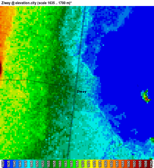
Below is the Elevation map of Ziway, which displays elevation range with different colors. Scale of the first map is from 1635 to 1700 m (5364 to 5577 ft) with average elevation of 1651 meters (=5417 ft) [note 1]
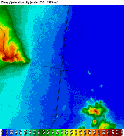
These maps also provides idea of topography and contour of this city, they are displayed at different zoom levels. More info about maps, scale and edge coordinates you can find below images.
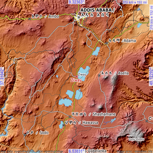
| \ | Map #1 | Map #2 | Topo.Map |
| Scale [m] | 1635..1700 m | 1635..1929 m | × |
| Scale [ft] | 5364..5577 ft | 5364..6329 ft | × |
| Average | 1651 m = 5417 ft | 1670 m = 5479 ft | × |
| Width | 9.68 km = 6 mi | 19.36 km = 12 mi | 309.7 km = 192.4 mi |
| Height | 9.68 km = 6 mi | 19.36 km = 12 mi | 309.7 km = 192.4 mi |
| ↑Max Latitude | 7.976852° | 8.02037° | 9.32363° |
| Latitude at center | 7.93333° | 7.93333° | 7.93333° |
| ↓Min Latitude | 7.889803° | 7.846271° | 6.53831° |
| ← Min Longitude | 38.672725° | 38.628779° | 37.31042° |
| Longitude center | 38.71667° | 38.71667° | 38.71667° |
| →Max Longitude | 38.760615° | 38.804561° | 40.12292° |
Nearby cities:
Cities around Ziway sort by population:
• Nazrēt elevation 1627 m
91.5 km,  41°
41°
• Hawassa 1697 m
100.4 km,  195°
195°
• Bishoftu 1978 m
95.5 km,  17°
17°
• Shashemenē 1924 m
82.5 km,  188°
188°
• Mojo 1774 m
85.2 km,  31°
31°
• Butajīra 2073 m
43.6 km,  297°
297°
• K’olīto 1781 m
97.8 km,  225°
225°
• Wenjī 1589 m
84.8 km,  47°
47°
• Huruta 2030 m
73.8 km,  70°
70°
• Tulu Bolo 2172 m
98.4 km,  325°
325°
• Sirre 1755 m
94.5 km,  63°
63°
• Kofelē 2666 m
96.6 km,  175°
175°
Multilingual:
 En español:
Ziway elevación 1649 m.
 En France:
Ziway élévation 1649 m.


Sources and notes:
- [note 1] Map square and city borders are not equal. Map elevation data is calculated only from area inside that square.
- [src 1] Elevation data from geonames database provided with same terms of usage.
- [src 2] The elevation map of Ziway is generated using elevation data from NASA's 3 arcsec (90m) resolution SRTM data.
- [src 3] Base (background) map © OpenStreetMap contributors tiles are generated by Geofabrik and OpenTopoMap.
Copyright & License:
This Ziway Elevation Map is licensed under CC BY-SA. You may reuse any part from this page, if you give a proper credit by linking to this URL:
 More info on terms of use page.