Wenjī elevation
Wenjī (Oromiya), Ethiopia elevation is 1589 meters and Wenjī elevation in feet is 5213 ft above sea level [src 1]. Wenjī is a populated place (feature code) with elevation that is 307 meters (1007 ft) smaller than average city elevation in Ethiopia.
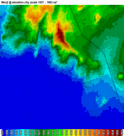
Below is the Elevation map of Wenjī, which displays elevation range with different colors. Scale of the first map is from 1537 to 1863 m (5043 to 6112 ft) with average elevation of 1599.8 meters (=5249 ft) [note 1]
These maps also provides idea of topography and contour of this city, they are displayed at different zoom levels. More info about maps, scale and edge coordinates you can find below images.
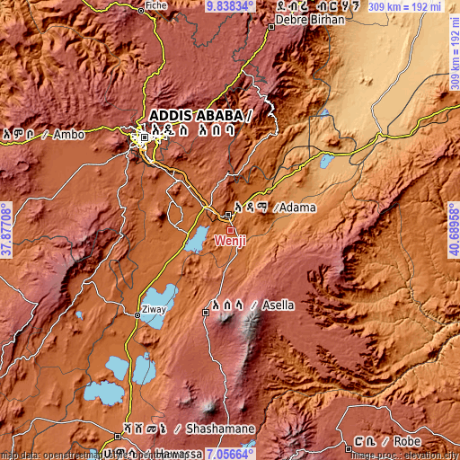
| \ | Map #1 | Map #2 | Topo.Map |
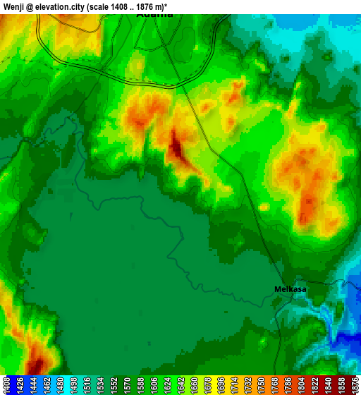
| Scale [m] | 1537..1863 m | 1408..1876 m | × |
| Scale [ft] | 5043..6112 ft | 4619..6155 ft | × |
| Average | 1599.8 m = 5249 ft | 1588.8 m = 5213 ft | × |
| Width | 9.67 km = 6 mi | 19.33 km = 12 mi | 309.3 km = 192.2 mi |
| Height | 9.67 km = 6 mi | 19.33 km = 12 mi | 309.3 km = 192.2 mi |
| ↑Max Latitude | 8.493466° | 8.536927° | 9.83834° |
| Latitude at center | 8.45° | 8.45° | 8.45° |
| ↓Min Latitude | 8.406529° | 8.363054° | 7.05664° |
| ← Min Longitude | 39.239385° | 39.195439° | 37.87708° |
| Longitude center | 39.28333° | 39.28333° | 39.28333° |
| →Max Longitude | 39.327275° | 39.371221° | 40.68958° |
Nearby cities:
Cities around Wenjī sort by population:
• Addis Ababa elevation 2405 m
87 km,  317°
317°
• Nazrēt 1627 m
11.3 km,  350°
350°
• Bishoftu 1978 m
47.5 km, 315°
• Ziway 1649 m
84.8 km,  227°
227°
• Mojo 1774 m
23.4 km,  310°
310°
• Butajīra 2073 m
107.5 km,  249°
249°
• Genet 2402 m
110.1 km, 308°
• Metahāra 958 m
85.7 km,  54°
54°
• Sebeta 2311 m
89.8 km, 305°
• Huruta 2030 m
34.2 km,  167°
167°
• Sirre 1755 m
26.5 km,  123°
123°
• Sendafa 2560 m
83.1 km,  339°
339°
Multilingual:
 En español:
Wenjī elevación 1589 m.
 En France:
Wenjī élévation 1589 m.


Sources and notes:
- [note 1] Map square and city borders are not equal. Map elevation data is calculated only from area inside that square.
- [src 1] Elevation data from geonames database provided with same terms of usage.
- [src 2] The elevation map of Wenjī is generated using elevation data from NASA's 3 arcsec (90m) resolution SRTM data.
- [src 3] Base (background) map © OpenStreetMap contributors tiles are generated by Geofabrik and OpenTopoMap.
Copyright & License:
This Wenjī Elevation Map is licensed under CC BY-SA. You may reuse any part from this page, if you give a proper credit by linking to this URL:
 More info on terms of use page.