Sendafa elevation
Sendafa (Oromiya), Ethiopia elevation is 2560 meters and Sendafa elevation in feet is 8399 ft above sea level [src 1]. Sendafa is a populated place (feature code) with elevation that is 664 meters (2178 ft) bigger than average city elevation in Ethiopia.
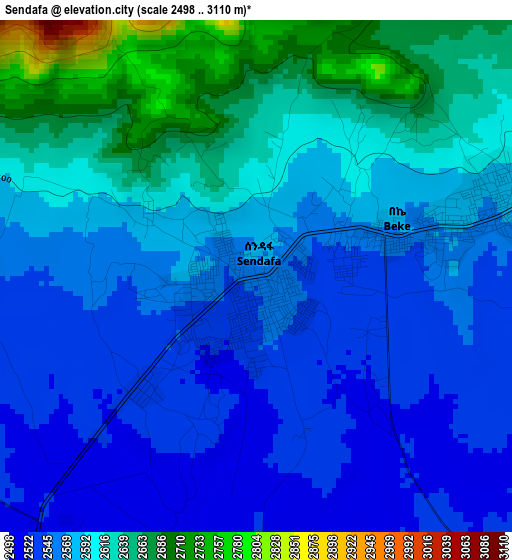
Below is the Elevation map of Sendafa, which displays elevation range with different colors. Scale of the first map is from 2498 to 3110 m (8196 to 10203 ft) with average elevation of 2585.6 meters (=8483 ft) [note 1]
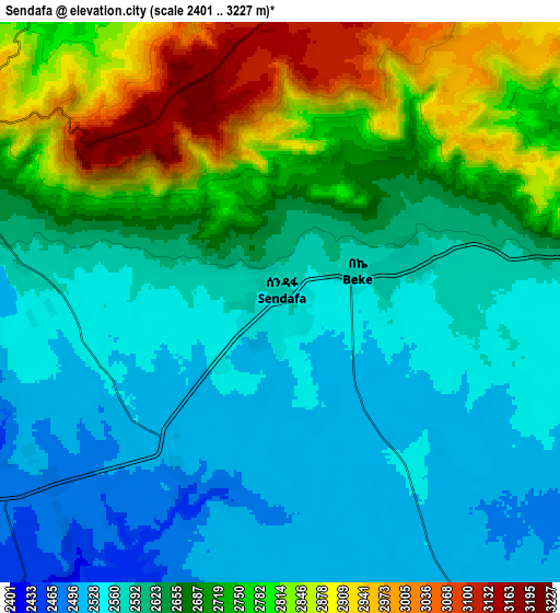
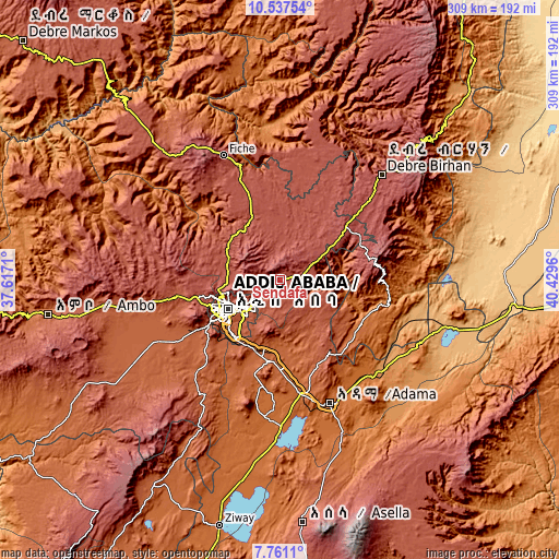
These maps also provides idea of topography and contour of this city, they are displayed at different zoom levels. More info about maps, scale and edge coordinates you can find below images.
| \ | Map #1 | Map #2 | Topo.Map |
| Scale [m] | 2498..3110 m | 2401..3227 m | × |
| Scale [ft] | 8196..10203 ft | 7877..10587 ft | × |
| Average | 2585.6 m = 8483 ft | 2661.7 m = 8733 ft | × |
| Width | 9.65 km = 6 mi | 19.3 km = 12 mi | 308.7 km = 191.8 mi |
| Height | 9.65 km = 6 mi | 19.3 km = 12 mi | 308.7 km = 191.8 mi |
| ↑Max Latitude | 9.195413° | 9.238791° | 10.53754° |
| Latitude at center | 9.15203° | 9.15203° | 9.15203° |
| ↓Min Latitude | 9.108641° | 9.065248° | 7.7611° |
| ← Min Longitude | 38.979405° | 38.935459° | 37.6171° |
| Longitude center | 39.02335° | 39.02335° | 39.02335° |
| →Max Longitude | 39.067295° | 39.111241° | 40.4296° |
Nearby cities:
Cities around Sendafa sort by population:
• Addis Ababa elevation 2405 m
33.5 km,  245°
245°
• Nazrēt 1627 m
72.1 km,  158°
158°
• Bishoftu 1978 m
44.7 km,  186°
186°
• Debre Birhan 2830 m
81 km,  43°
43°
• Mojo 1774 m
63.8 km,  170°
170°
• Fichē 2792 m
78.8 km,  336°
336°
• Genet 2402 m
58.2 km,  260°
260°
• Metahāra 958 m
102 km,  105°
105°
• Sebeta 2311 m
51.8 km,  239°
239°
• Wenjī 1589 m
83.1 km, 159°
• Gebre Guracha 2539 m
99.3 km,  316°
316°
• Ādīs ‘Alem 2315 m
69.7 km, 259°
Multilingual:
 En español:
Sendafa elevación 2560 m.
 En France:
Sendafa élévation 2560 m.
 Auf Deutsch:
Sendafa höhe über dem Meeresspiegel ist 2560 m.

Sources and notes:
- [note 1] Map square and city borders are not equal. Map elevation data is calculated only from area inside that square.
- [src 1] Elevation data from geonames database provided with same terms of usage.
- [src 2] The elevation map of Sendafa is generated using elevation data from NASA's 3 arcsec (90m) resolution SRTM data.
- [src 3] Base (background) map © OpenStreetMap contributors tiles are generated by Geofabrik and OpenTopoMap.
Copyright & License:
This Sendafa Elevation Map is licensed under CC BY-SA. You may reuse any part from this page, if you give a proper credit by linking to this URL:
 More info on terms of use page.