Ginir elevation
Ginir (Oromiya), Ethiopia elevation is 1945 meters and Ginir elevation in feet is 6381 ft above sea level [src 1]. Ginir is a populated place (feature code) with elevation that is 49 meters (161 ft) bigger than average city elevation in Ethiopia.
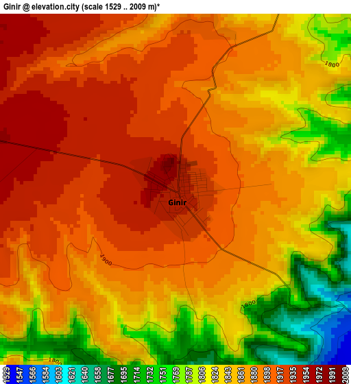
Below is the Elevation map of Ginir, which displays elevation range with different colors. Scale of the first map is from 1529 to 2009 m (5016 to 6591 ft) with average elevation of 1863.1 meters (=6113 ft) [note 1]
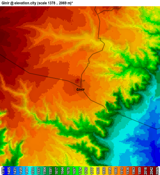
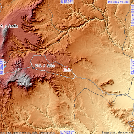
These maps also provides idea of topography and contour of this city, they are displayed at different zoom levels. More info about maps, scale and edge coordinates you can find below images.
| \ | Map #1 | Map #2 | Topo.Map |
| Scale [m] | 1529..2009 m | 1378..2069 m | × |
| Scale [ft] | 5016..6591 ft | 4521..6788 ft | × |
| Average | 1863.1 m = 6113 ft | 1810.2 m = 5939 ft | × |
| Width | 9.7 km = 6 mi | 19.39 km = 12 mi | 310.3 km = 192.8 mi |
| Height | 9.7 km = 6 mi | 19.39 km = 12 mi | 310.3 km = 192.8 mi |
| ↑Max Latitude | 7.183122° | 7.226721° | 8.5326° |
| Latitude at center | 7.13952° | 7.13952° | 7.13952° |
| ↓Min Latitude | 7.095913° | 7.052303° | 5.74218° |
| ← Min Longitude | 40.666885° | 40.622939° | 39.30458° |
| Longitude center | 40.71083° | 40.71083° | 40.71083° |
| →Max Longitude | 40.754775° | 40.798721° | 42.11708° |
Nearby cities:
Cities around Ginir sort by population:
• Goba elevation 2682 m
81.4 km,  260°
260°
• Āsbe Teferī 1750 m
217.1 km,  4°
4°
• Āsasa 2369 m
166.8 km,  268°
268°
• Metahāra 958 m
214.4 km,  335°
335°
• Dodola 2464 m
169.4 km, 264°
• Bedēsa 1683 m
195.9 km, 2°
• Wenjī 1589 m
214.4 km,  312°
312°
• Gelemso 1795 m
187.7 km,  353°
353°
• Huruta 2030 m
187.4 km, 306°
• Āwash 917 m
213.6 km, 343°
• Sirre 1755 m
188.2 km, 314°
• Kofelē 2666 m
212.8 km, 267°
Multilingual:
 En español:
Ginir elevación 1945 m.
 En France:
Ginir élévation 1945 m.


Sources and notes:
- [note 1] Map square and city borders are not equal. Map elevation data is calculated only from area inside that square.
- [src 1] Elevation data from geonames database provided with same terms of usage.
- [src 2] The elevation map of Ginir is generated using elevation data from NASA's 3 arcsec (90m) resolution SRTM data.
- [src 3] Base (background) map © OpenStreetMap contributors tiles are generated by Geofabrik and OpenTopoMap.
Copyright & License:
This Ginir Elevation Map is licensed under CC BY-SA. You may reuse any part from this page, if you give a proper credit by linking to this URL:
 More info on terms of use page.