Camporrells elevation
Camporrells (Aragon, Provincia de Huesca), Spain elevation is 619 meters and Camporrells elevation in feet is 2031 ft above sea level [src 1]. Camporrells is a seat of a third-order administrative division (feature code) with elevation that is 16 meters (52 ft) bigger than average city elevation in Spain.
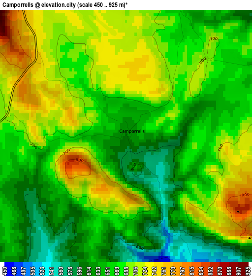
Below is the Elevation map of Camporrells, which displays elevation range with different colors. Scale of the first map is from 450 to 925 m (1476 to 3035 ft) with average elevation of 675.3 meters (=2216 ft) [note 1]
These maps also provides idea of topography and contour of this city, they are displayed at different zoom levels. More info about maps, scale and edge coordinates you can find below images.
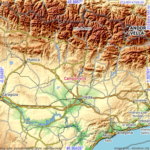
| \ | Map #1 | Topo.Map |
| Scale [m] | 450..925 m | × |
| Scale [ft] | 1476..3035 ft | × |
| Average | 675.3 m = 2216 ft | × |
| Width | 7.27 km = 4.5 mi | 232.5 km = 144.5 mi |
| Height | 7.27 km = 4.5 mi | 232.5 km = 144.5 mi |
| ↑Max Latitude | 41.991231° | 42.9957° |
| Latitude at center | 41.95856° | 41.95856° |
| ↓Min Latitude | 41.925873° | 40.90426° |
| ← Min Longitude | 0.477415° | -0.88489° |
| Longitude center | 0.52136° | 0.52136° |
| →Max Longitude | 0.565305° | 1.92761° |
Nearby cities:
Cities around Camporrells sort by population:
• Binéfar elevation 285 m
22.2 km,  237°
237°
• Tamarit de Llitera / Tamarite de Litera 369 m
12.9 km,  219°
219°
• Almenar 307 m
18.5 km,  167°
167°
• Alfarràs 264 m
16.6 km,  161°
161°
• el Torricó / Altorricon 262 m
19.5 km,  207°
207°
• Benavarri / Benabarre 739 m
16.7 km,  348°
348°
• Fonz 452 m
22.4 km,  284°
284°
• Albelda 362 m
11.5 km, 206°
• Os de Balaguer 462 m
19 km,  120°
120°
• Àger 579 m
20.8 km,  77°
77°
• Algerri 348 m
18.6 km,  149°
149°
• Baells 618 m
5.1 km,  263°
263°
Multilingual:
 En español:
Camporrells elevación 619 m.
 En France:
Camporrells élévation 619 m.
 Auf Deutsch:
Camporrells höhe über dem Meeresspiegel ist 619 m.

Sources and notes:
- [note 1] Map square and city borders are not equal. Map elevation data is calculated only from area inside that square.
- [src 1] Elevation data from geonames database provided with same terms of usage.
- [src 2] The elevation map of Camporrells is generated using elevation data from NASA's 3 arcsec (90m) resolution SRTM data.
- [src 3] Base (background) map © OpenStreetMap contributors tiles are generated by Geofabrik and OpenTopoMap.
Copyright & License:
This Camporrells Elevation Map is licensed under CC BY-SA. You may reuse any part from this page, if you give a proper credit by linking to this URL:
 More info on terms of use page.