Àger elevation
Àger (Catalonia, Província de Lleida), Spain elevation is 579 meters and Àger elevation in feet is 1900 ft above sea level [src 1]. Àger is a seat of a third-order administrative division (feature code) with elevation that is 24 meters (79 ft) smaller than average city elevation in Spain.
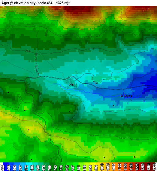
Below is the Elevation map of Àger, which displays elevation range with different colors. Scale of the first map is from 434 to 1328 m (1424 to 4357 ft) with average elevation of 756.3 meters (=2481 ft) [note 1]
These maps also provides idea of topography and contour of this city, they are displayed at different zoom levels. More info about maps, scale and edge coordinates you can find below images.
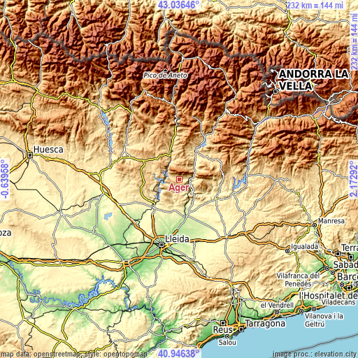
| \ | Map #1 | Topo.Map |
| Scale [m] | 434..1328 m | × |
| Scale [ft] | 1424..4357 ft | × |
| Average | 756.3 m = 2481 ft | × |
| Width | 7.26 km = 4.5 mi | 232.4 km = 144.4 mi |
| Height | 7.26 km = 4.5 mi | 232.4 km = 144.4 mi |
| ↑Max Latitude | 42.032649° | 43.03646° |
| Latitude at center | 42° | 42° |
| ↓Min Latitude | 41.967334° | 40.94638° |
| ← Min Longitude | 0.722725° | -0.63958° |
| Longitude center | 0.76667° | 0.76667° |
| →Max Longitude | 0.810615° | 2.17292° |
Nearby cities:
Cities around Àger sort by population:
• Balaguer elevation 223 m
23.5 km,  171°
171°
• Tremp 475 m
21.4 km,  29°
29°
• Artesa de Segre 333 m
25.9 km,  116°
116°
• Alfarràs 264 m
25.4 km,  216°
216°
• Camarasa 294 m
16.7 km,  146°
146°
• Os de Balaguer 462 m
14.6 km,  195°
195°
• Algerri 348 m
23.2 km,  207°
207°
• Cubells 493 m
23 km,  136°
136°
• Camporrells 619 m
20.8 km,  257°
257°
• Llimiana 784 m
14.9 km,  56°
56°
• Baells 618 m
25.9 km, 258°
• Castelló de Farfanya 337 m
20.6 km,  187°
187°
Multilingual:
 En español:
Àger elevación 579 m.
 En France:
Àger élévation 579 m.


Sources and notes:
- [note 1] Map square and city borders are not equal. Map elevation data is calculated only from area inside that square.
- [src 1] Elevation data from geonames database provided with same terms of usage.
- [src 2] The elevation map of Àger is generated using elevation data from NASA's 3 arcsec (90m) resolution SRTM data.
- [src 3] Base (background) map © OpenStreetMap contributors tiles are generated by Geofabrik and OpenTopoMap.
Copyright & License:
This Àger Elevation Map is licensed under CC BY-SA. You may reuse any part from this page, if you give a proper credit by linking to this URL:
 More info on terms of use page.