Tamarit de Llitera / Tamarite de Litera elevation
Tamarit de Llitera / Tamarite de Litera (Aragon, Provincia de Huesca), Spain elevation is 369 meters and Tamarit de Llitera / Tamarite de Litera elevation in feet is 1211 ft above sea level [src 1]. Tamarit de Llitera / Tamarite de Litera is a populated place (feature code) with elevation that is 234 meters (768 ft) smaller than average city elevation in Spain.
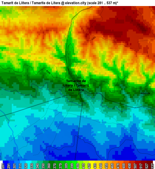
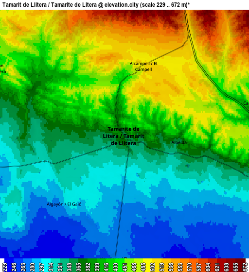
Below is the Elevation map of Tamarit de Llitera / Tamarite de Litera, which displays elevation range with different colors. Scale of the first map is from 281 to 537 m (922 to 1762 ft) with average elevation of 387.1 meters (=1270 ft) [note 1]
These maps also provides idea of topography and contour of this city, they are displayed at different zoom levels. More info about maps, scale and edge coordinates you can find below images.
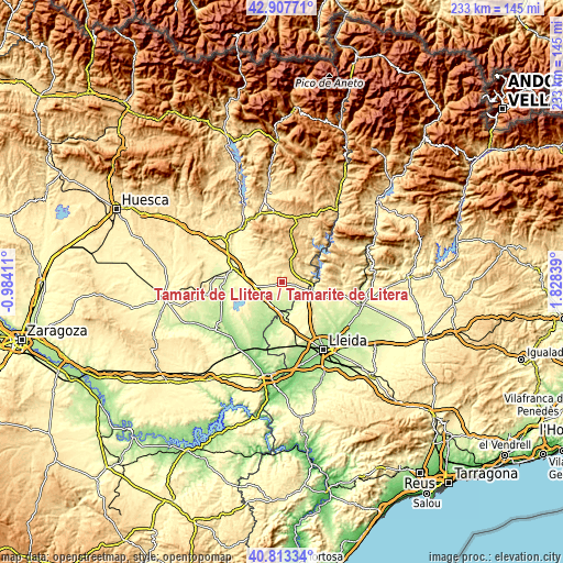
| \ | Map #1 | Map #2 | Topo.Map |
| Scale [m] | 281..537 m | 229..672 m | × |
| Scale [ft] | 922..1762 ft | 751..2205 ft | × |
| Average | 387.1 m = 1270 ft | 390.8 m = 1282 ft | × |
| Width | 7.28 km = 4.5 mi | 14.55 km = 9 mi | 232.9 km = 144.7 mi |
| Height | 7.28 km = 4.5 mi | 14.55 km = 9 mi | 232.9 km = 144.7 mi |
| ↑Max Latitude | 41.901816° | 41.934516° | 42.90771° |
| Latitude at center | 41.8691° | 41.8691° | 41.8691° |
| ↓Min Latitude | 41.836367° | 41.803617° | 40.81334° |
| ← Min Longitude | 0.378195° | 0.334249° | -0.98411° |
| Longitude center | 0.42214° | 0.42214° | 0.42214° |
| →Max Longitude | 0.466085° | 0.510031° | 1.82839° |
Nearby cities:
Cities around Tamarit de Llitera / Tamarite de Litera sort by population:
• Monzón elevation 280 m
19.4 km,  283°
283°
• Binéfar 285 m
10.8 km,  259°
259°
• Almacelles 253 m
15.3 km,  175°
175°
• Almenar 307 m
14.6 km,  123°
123°
• Alfarràs 264 m
14.6 km,  113°
113°
• Binaced 283 m
19 km, 255°
• el Torricó / Altorricon 262 m
7.4 km,  185°
185°
• Albelda 362 m
3.2 km,  97°
97°
• Esplús 277 m
14.4 km,  237°
237°
• Algerri 348 m
18.7 km, 108°
• Camporrells 619 m
12.9 km,  39°
39°
• Baells 618 m
9.9 km,  18°
18°
Multilingual:
 En español:
Tamarite de Litera elevación 369 m.
 En France:
Tamarit de Llitera / Tamarite de Litera élévation 369 m.
 Auf Deutsch:
Tamarit de Llitera / Tamarite de Litera höhe über dem Meeresspiegel ist 369 m.
 На русском:
Tamarit de Llitera / Tamarite de Litera высота над уровнем моря 369 м
Sources and notes:
- [note 1] Map square and city borders are not equal. Map elevation data is calculated only from area inside that square.
- [src 1] Elevation data from geonames database provided with same terms of usage.
- [src 2] The elevation map of Tamarit de Llitera / Tamarite de Litera is generated using elevation data from NASA's 3 arcsec (90m) resolution SRTM data.
- [src 3] Base (background) map © OpenStreetMap contributors tiles are generated by Geofabrik and OpenTopoMap.
Copyright & License:
This Tamarit de Llitera / Tamarite de Litera Elevation Map is licensed under CC BY-SA. You may reuse any part from this page, if you give a proper credit by linking to this URL:
 More info on terms of use page.