Binéfar elevation
Binéfar (Aragon, Provincia de Huesca), Spain elevation is 285 meters and Binéfar elevation in feet is 935 ft above sea level [src 1]. Binéfar is a seat of a third-order administrative division (feature code) with elevation that is 318 meters (1043 ft) smaller than average city elevation in Spain.
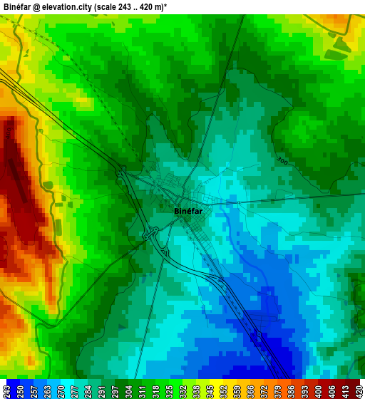
Below is the Elevation map of Binéfar, which displays elevation range with different colors. Scale of the first map is from 243 to 420 m (797 to 1378 ft) with average elevation of 306.6 meters (=1006 ft) [note 1]
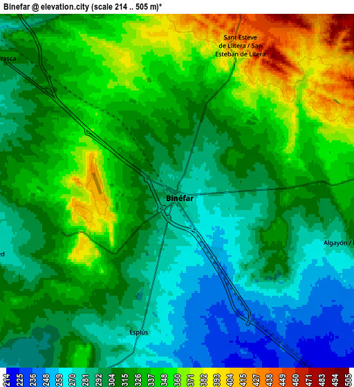
These maps also provides idea of topography and contour of this city, they are displayed at different zoom levels. More info about maps, scale and edge coordinates you can find below images.
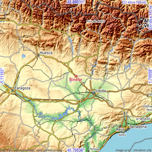
| \ | Map #1 | Map #2 | Topo.Map |
| Scale [m] | 243..420 m | 214..505 m | × |
| Scale [ft] | 797..1378 ft | 702..1657 ft | × |
| Average | 306.6 m = 1006 ft | 317.1 m = 1040 ft | × |
| Width | 7.28 km = 4.5 mi | 14.56 km = 9 mi | 232.9 km = 144.7 mi |
| Height | 7.28 km = 4.5 mi | 14.56 km = 9 mi | 232.9 km = 144.7 mi |
| ↑Max Latitude | 41.884136° | 41.916844° | 42.89031° |
| Latitude at center | 41.85141° | 41.85141° | 41.85141° |
| ↓Min Latitude | 41.818668° | 41.785909° | 40.79536° |
| ← Min Longitude | 0.250385° | 0.206439° | -1.11192° |
| Longitude center | 0.29433° | 0.29433° | 0.29433° |
| →Max Longitude | 0.338275° | 0.382221° | 1.70058° |
Nearby cities:
Cities around Binéfar sort by population:
• Monzón elevation 280 m
10.6 km,  308°
308°
• Almacelles 253 m
17.8 km,  138°
138°
• Tamarit de Llitera / Tamarite de Litera 369 m
10.8 km,  79°
79°
• Binaced 283 m
8.3 km,  249°
249°
• el Torricó / Altorricon 262 m
11.3 km,  118°
118°
• Fonz 452 m
17.9 km,  350°
350°
• Albelda 362 m
13.8 km, 83°
• Esplús 277 m
6.1 km,  194°
194°
• Castejón del Puente 358 m
16.6 km,  317°
317°
• Pueyo de Santa Cruz 249 m
11.4 km,  273°
273°
• Alfántega 239 m
12.4 km,  258°
258°
• Baells 618 m
17.8 km,  50°
50°
Multilingual:
 En español:
Binéfar elevación 285 m.
 En France:
Binéfar élévation 285 m.


Sources and notes:
- [note 1] Map square and city borders are not equal. Map elevation data is calculated only from area inside that square.
- [src 1] Elevation data from geonames database provided with same terms of usage.
- [src 2] The elevation map of Binéfar is generated using elevation data from NASA's 3 arcsec (90m) resolution SRTM data.
- [src 3] Base (background) map © OpenStreetMap contributors tiles are generated by Geofabrik and OpenTopoMap.
Copyright & License:
This Binéfar Elevation Map is licensed under CC BY-SA. You may reuse any part from this page, if you give a proper credit by linking to this URL:
 More info on terms of use page.