Fonz elevation
Fonz (Aragon, Provincia de Huesca), Spain elevation is 452 meters and Fonz elevation in feet is 1483 ft above sea level [src 1]. Fonz is a seat of a third-order administrative division (feature code) with elevation that is 151 meters (495 ft) smaller than average city elevation in Spain.
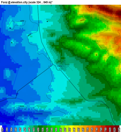
Below is the Elevation map of Fonz, which displays elevation range with different colors. Scale of the first map is from 324 to 849 m (1063 to 2785 ft) with average elevation of 459.3 meters (=1507 ft) [note 1]
These maps also provides idea of topography and contour of this city, they are displayed at different zoom levels. More info about maps, scale and edge coordinates you can find below images.
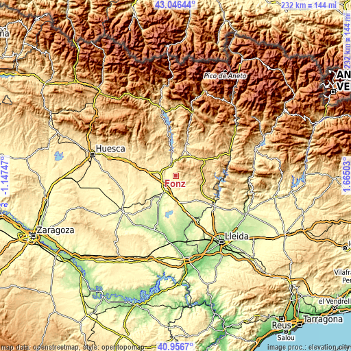
| \ | Map #1 | Topo.Map |
| Scale [m] | 324..849 m | × |
| Scale [ft] | 1063..2785 ft | × |
| Average | 459.3 m = 1507 ft | × |
| Width | 7.26 km = 4.5 mi | 232.4 km = 144.4 mi |
| Height | 7.26 km = 4.5 mi | 232.3 km = 144.3 mi |
| ↑Max Latitude | 42.042794° | 43.04644° |
| Latitude at center | 42.01015° | 42.01015° |
| ↓Min Latitude | 41.977489° | 40.9567° |
| ← Min Longitude | 0.214835° | -1.14747° |
| Longitude center | 0.25878° | 0.25878° |
| →Max Longitude | 0.302725° | 1.66503° |
Nearby cities:
Cities around Fonz sort by population:
• Monzón elevation 280 m
12.3 km,  205°
205°
• Barbastro 338 m
11.3 km,  284°
284°
• Binéfar 285 m
17.9 km,  170°
170°
• Estadilla 447 m
5.3 km,  346°
346°
• Castejón del Puente 358 m
9.9 km,  236°
236°
• Pueyo de Santa Cruz 249 m
18.9 km, 206°
• Ilche 322 m
17.7 km,  250°
250°
• Castillazuelo 368 m
17.2 km,  291°
291°
• Estada 375 m
7.2 km,  342°
342°
• Salas Bajas 460 m
17.6 km,  304°
304°
• Secastilla 610 m
19 km,  2°
2°
• Baells 618 m
17.8 km,  110°
110°
Multilingual:
 En español:
Fonz elevación 452 m.
 En France:
Fonz élévation 452 m.


Sources and notes:
- [note 1] Map square and city borders are not equal. Map elevation data is calculated only from area inside that square.
- [src 1] Elevation data from geonames database provided with same terms of usage.
- [src 2] The elevation map of Fonz is generated using elevation data from NASA's 3 arcsec (90m) resolution SRTM data.
- [src 3] Base (background) map © OpenStreetMap contributors tiles are generated by Geofabrik and OpenTopoMap.
Copyright & License:
This Fonz Elevation Map is licensed under CC BY-SA. You may reuse any part from this page, if you give a proper credit by linking to this URL:
 More info on terms of use page.