Salas Bajas elevation
Salas Bajas (Aragon, Provincia de Huesca), Spain elevation is 460 meters and Salas Bajas elevation in feet is 1509 ft above sea level [src 1]. Salas Bajas is a seat of a third-order administrative division (feature code) with elevation that is 143 meters (469 ft) smaller than average city elevation in Spain.
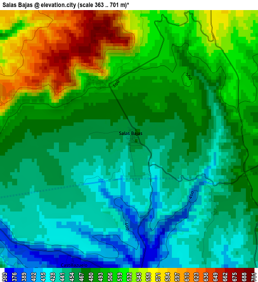
Below is the Elevation map of Salas Bajas, which displays elevation range with different colors. Scale of the first map is from 363 to 701 m (1191 to 2300 ft) with average elevation of 481.5 meters (=1580 ft) [note 1]
These maps also provides idea of topography and contour of this city, they are displayed at different zoom levels. More info about maps, scale and edge coordinates you can find below images.
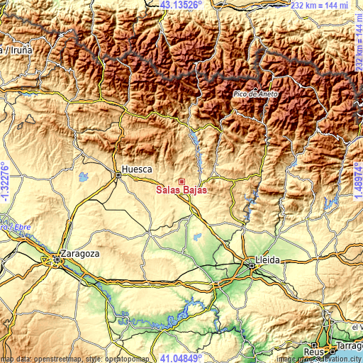
| \ | Map #1 | Topo.Map |
| Scale [m] | 363..701 m | × |
| Scale [ft] | 1191..2300 ft | × |
| Average | 481.5 m = 1580 ft | × |
| Width | 7.25 km = 4.5 mi | 232 km = 144.2 mi |
| Height | 7.25 km = 4.5 mi | 232 km = 144.2 mi |
| ↑Max Latitude | 42.133058° | 43.13526° |
| Latitude at center | 42.10046° | 42.10046° |
| ↓Min Latitude | 42.067845° | 41.04849° |
| ← Min Longitude | 0.039545° | -1.32276° |
| Longitude center | 0.08349° | 0.08349° |
| →Max Longitude | 0.127435° | 1.48974° |
Nearby cities:
Cities around Salas Bajas sort by population:
• Barbastro elevation 338 m
8 km,  153°
153°
• Salas Altas 503 m
2 km,  320°
320°
• Alquézar 637 m
9.3 km,  329°
329°
• Naval 630 m
11.9 km,  28°
28°
• Pozán de Vero 412 m
4.8 km,  245°
245°
• Castillazuelo 368 m
3.9 km,  202°
202°
• Estada 375 m
12.7 km,  104°
104°
• Azara 436 m
9.9 km, 250°
• Peraltilla 420 m
9.9 km,  238°
238°
• Adahuesca 618 m
9.1 km,  303°
303°
• Azlor 487 m
10.7 km,  266°
266°
• Colungo 621 m
8 km,  350°
350°
Multilingual:
 En español:
Salas Bajas elevación 460 m.
 En France:
Salas Bajas élévation 460 m.
 Auf Deutsch:
Salas Bajas höhe über dem Meeresspiegel ist 460 m.

Sources and notes:
- [note 1] Map square and city borders are not equal. Map elevation data is calculated only from area inside that square.
- [src 1] Elevation data from geonames database provided with same terms of usage.
- [src 2] The elevation map of Salas Bajas is generated using elevation data from NASA's 3 arcsec (90m) resolution SRTM data.
- [src 3] Base (background) map © OpenStreetMap contributors tiles are generated by Geofabrik and OpenTopoMap.
Copyright & License:
This Salas Bajas Elevation Map is licensed under CC BY-SA. You may reuse any part from this page, if you give a proper credit by linking to this URL:
 More info on terms of use page.