Chantada elevation
Chantada (Galicia, Provincia de Lugo), Spain elevation is 491 meters and Chantada elevation in feet is 1611 ft above sea level [src 1]. Chantada is a seat of a third-order administrative division (feature code) with elevation that is 112 meters (367 ft) smaller than average city elevation in Spain.
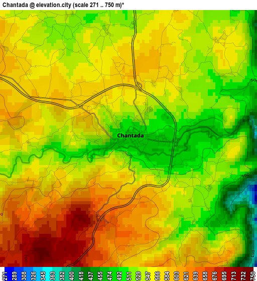
Below is the Elevation map of Chantada, which displays elevation range with different colors. Scale of the first map is from 271 to 750 m (889 to 2461 ft) with average elevation of 556.8 meters (=1827 ft) [note 1]
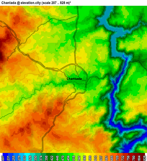
These maps also provides idea of topography and contour of this city, they are displayed at different zoom levels. More info about maps, scale and edge coordinates you can find below images.
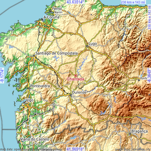
| \ | Map #1 | Map #2 | Topo.Map |
| Scale [m] | 271..750 m | 207..828 m | × |
| Scale [ft] | 889..2461 ft | 679..2717 ft | × |
| Average | 556.8 m = 1827 ft | 547.9 m = 1798 ft | × |
| Width | 7.19 km = 4.5 mi | 14.39 km = 8.9 mi | 230.2 km = 143 mi |
| Height | 7.19 km = 4.5 mi | 14.39 km = 8.9 mi | 230.1 km = 143 mi |
| ↑Max Latitude | 42.641095° | 42.673413° | 43.63514° |
| Latitude at center | 42.60876° | 42.60876° | 42.60876° |
| ↓Min Latitude | 42.576408° | 42.544039° | 41.56518° |
| ← Min Longitude | -7.815095° | -7.859041° | -9.1774° |
| Longitude center | -7.77115° | -7.77115° | -7.77115° |
| →Max Longitude | -7.727205° | -7.683259° | -6.3649° |
Nearby cities:
Cities around Chantada sort by population:
• Monterroso elevation 549 m
21.1 km,  345°
345°
• Taboada 623 m
10.9 km,  337°
337°
• Rodeiro 656 m
15.8 km,  287°
287°
• Pantón 304 m
17.4 km,  126°
126°
• Sober 396 m
22.3 km,  137°
137°
• Cea 518 m
23.1 km,  229°
229°
• Nogueira de Ramuín 572 m
21.4 km,  175°
175°
• Dozón 722 m
20.3 km,  261°
261°
• Luintra 637 m
22.4 km,  170°
170°
• Piñor 547 m
22.3 km,  237°
237°
• Vilamarín 509 m
18.8 km,  211°
211°
• Carballedo 575 m
10.7 km, 205°
Multilingual:
 En español:
Chantada elevación 491 m.
 En France:
Chantada élévation 491 m.
 Auf Deutsch:
Chantada höhe über dem Meeresspiegel ist 491 m.

Sources and notes:
- [note 1] Map square and city borders are not equal. Map elevation data is calculated only from area inside that square.
- [src 1] Elevation data from geonames database provided with same terms of usage.
- [src 2] The elevation map of Chantada is generated using elevation data from NASA's 3 arcsec (90m) resolution SRTM data.
- [src 3] Base (background) map © OpenStreetMap contributors tiles are generated by Geofabrik and OpenTopoMap.
Copyright & License:
This Chantada Elevation Map is licensed under CC BY-SA. You may reuse any part from this page, if you give a proper credit by linking to this URL:
 More info on terms of use page.