Luintra elevation
Luintra (Galicia, Provincia de Ourense), Spain elevation is 637 meters and Luintra elevation in feet is 2090 ft above sea level [src 1]. Luintra is a populated place (feature code) with elevation that is 34 meters (112 ft) bigger than average city elevation in Spain.
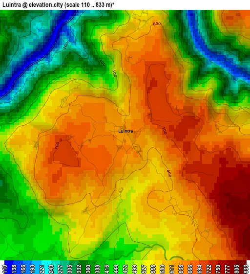
Below is the Elevation map of Luintra, which displays elevation range with different colors. Scale of the first map is from 110 to 833 m (361 to 2733 ft) with average elevation of 536.8 meters (=1761 ft) [note 1]
These maps also provides idea of topography and contour of this city, they are displayed at different zoom levels. More info about maps, scale and edge coordinates you can find below images.
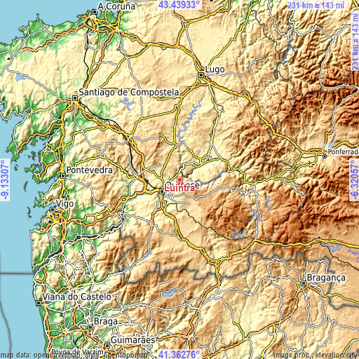
| \ | Map #1 | Topo.Map |
| Scale [m] | 110..833 m | × |
| Scale [ft] | 361..2733 ft | × |
| Average | 536.8 m = 1761 ft | × |
| Width | 7.22 km = 4.5 mi | 230.9 km = 143.5 mi |
| Height | 7.22 km = 4.5 mi | 230.9 km = 143.5 mi |
| ↑Max Latitude | 42.442078° | 43.43933° |
| Latitude at center | 42.40964° | 42.40964° |
| ↓Min Latitude | 42.377185° | 41.36276° |
| ← Min Longitude | -7.770765° | -9.13307° |
| Longitude center | -7.72682° | -7.72682° |
| →Max Longitude | -7.682875° | -6.32057° |
Nearby cities:
Cities around Luintra sort by population:
• Ourense elevation 146 m
13.9 km,  234°
234°
• Pereiro de Aguiar 327 m
9.4 km,  220°
220°
• Coles 341 m
8.8 km,  263°
263°
• Maceda 589 m
16.8 km,  158°
158°
• Pantón 304 m
15.8 km,  41°
41°
• Sober 396 m
12.9 km,  63°
63°
• Nogueira de Ramuín 572 m
2.1 km,  293°
293°
• Lobios 532 m
16 km,  90°
90°
• Esgos 581 m
9.7 km,  165°
165°
• Carballedo 575 m
15 km,  326°
326°
• Vilamarín 509 m
14.8 km, 294°
• Vilarnaz 393 m
11.2 km, 264°
Multilingual:
 En español:
Luintra elevación 637 m.
 En France:
Luintra élévation 637 m.


Sources and notes:
- [note 1] Map square and city borders are not equal. Map elevation data is calculated only from area inside that square.
- [src 1] Elevation data from geonames database provided with same terms of usage.
- [src 2] The elevation map of Luintra is generated using elevation data from NASA's 3 arcsec (90m) resolution SRTM data.
- [src 3] Base (background) map © OpenStreetMap contributors tiles are generated by Geofabrik and OpenTopoMap.
Copyright & License:
This Luintra Elevation Map is licensed under CC BY-SA. You may reuse any part from this page, if you give a proper credit by linking to this URL:
 More info on terms of use page.