Sober elevation
Sober (Galicia, Provincia de Lugo), Spain elevation is 396 meters and Sober elevation in feet is 1299 ft above sea level [src 1]. Sober is a seat of a third-order administrative division (feature code) with elevation that is 207 meters (679 ft) smaller than average city elevation in Spain.
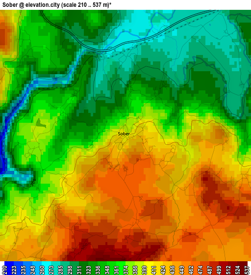
Below is the Elevation map of Sober, which displays elevation range with different colors. Scale of the first map is from 210 to 537 m (689 to 1762 ft) with average elevation of 379.4 meters (=1245 ft) [note 1]
These maps also provides idea of topography and contour of this city, they are displayed at different zoom levels. More info about maps, scale and edge coordinates you can find below images.
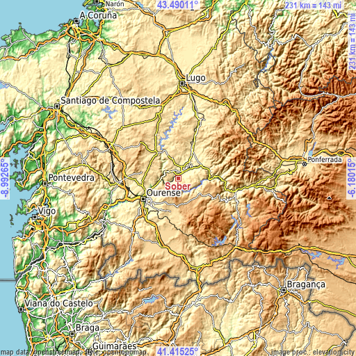
| \ | Map #1 | Topo.Map |
| Scale [m] | 210..537 m | × |
| Scale [ft] | 689..1762 ft | × |
| Average | 379.4 m = 1245 ft | × |
| Width | 7.21 km = 4.5 mi | 230.7 km = 143.4 mi |
| Height | 7.21 km = 4.5 mi | 230.7 km = 143.4 mi |
| ↑Max Latitude | 42.493682° | 43.49011° |
| Latitude at center | 42.46127° | 42.46127° |
| ↓Min Latitude | 42.428842° | 41.41525° |
| ← Min Longitude | -7.630345° | -8.99265° |
| Longitude center | -7.5864° | -7.5864° |
| →Max Longitude | -7.542455° | -6.18015° |
Nearby cities:
Cities around Sober sort by population:
• Monforte de Lemos elevation 295 m
8.9 km,  41°
41°
• Coles 341 m
21.4 km,  251°
251°
• Pantón 304 m
6.3 km,  349°
349°
• Nogueira de Ramuín 572 m
14.3 km, 249°
• Lobios 532 m
7.5 km,  143°
143°
• A Pobra do Brollon 387 m
19.1 km,  56°
56°
• Castro Caldelas 749 m
16.4 km,  126°
126°
• Esgos 581 m
17.6 km,  211°
211°
• Luintra 637 m
12.9 km,  243°
243°
• Montederramo 906 m
21.8 km,  161°
161°
• Carballedo 575 m
21 km,  288°
288°
• Bóveda 366 m
20.3 km,  26°
26°
Multilingual:
 En español:
Sober elevación 396 m.
 En France:
Sober élévation 396 m.


Sources and notes:
- [note 1] Map square and city borders are not equal. Map elevation data is calculated only from area inside that square.
- [src 1] Elevation data from geonames database provided with same terms of usage.
- [src 2] The elevation map of Sober is generated using elevation data from NASA's 3 arcsec (90m) resolution SRTM data.
- [src 3] Base (background) map © OpenStreetMap contributors tiles are generated by Geofabrik and OpenTopoMap.
Copyright & License:
This Sober Elevation Map is licensed under CC BY-SA. You may reuse any part from this page, if you give a proper credit by linking to this URL:
 More info on terms of use page.