Pereiro de Aguiar elevation
Pereiro de Aguiar (Galicia, Provincia de Ourense), Spain elevation is 327 meters and Pereiro de Aguiar elevation in feet is 1073 ft above sea level [src 1]. Pereiro de Aguiar is a populated place (feature code) with elevation that is 276 meters (906 ft) smaller than average city elevation in Spain.
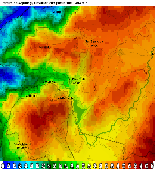
Below is the Elevation map of Pereiro de Aguiar, which displays elevation range with different colors. Scale of the first map is from 109 to 493 m (358 to 1617 ft) with average elevation of 353.7 meters (=1160 ft) [note 1]
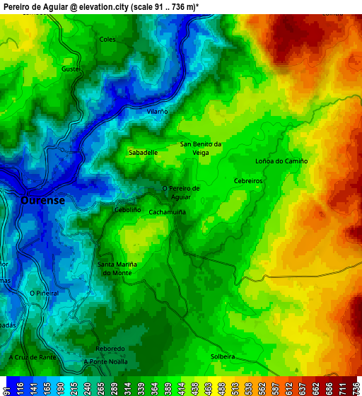
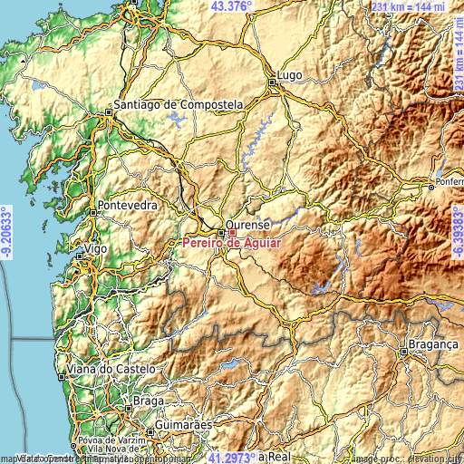
These maps also provides idea of topography and contour of this city, they are displayed at different zoom levels. More info about maps, scale and edge coordinates you can find below images.
| \ | Map #1 | Map #2 | Topo.Map |
| Scale [m] | 109..493 m | 91..736 m | × |
| Scale [ft] | 358..1617 ft | 299..2415 ft | × |
| Average | 353.7 m = 1160 ft | 363.7 m = 1193 ft | × |
| Width | 7.22 km = 4.5 mi | 14.45 km = 9 mi | 231.1 km = 143.6 mi |
| Height | 7.22 km = 4.5 mi | 14.45 km = 9 mi | 231.1 km = 143.6 mi |
| ↑Max Latitude | 42.377712° | 42.410166° | 43.376° |
| Latitude at center | 42.34524° | 42.34524° | 42.34524° |
| ↓Min Latitude | 42.312752° | 42.280247° | 41.2973° |
| ← Min Longitude | -7.844025° | -7.887971° | -9.20633° |
| Longitude center | -7.80008° | -7.80008° | -7.80008° |
| →Max Longitude | -7.756135° | -7.712189° | -6.39383° |
Nearby cities:
Cities around Pereiro de Aguiar sort by population:
• Ourense elevation 146 m
5.3 km,  259°
259°
• Coles 341 m
6.7 km,  335°
335°
• Maceda 589 m
14.9 km,  124°
124°
• Toén 369 m
13 km, 256°
• Nogueira de Ramuín 572 m
9 km,  27°
27°
• Amoeiro 415 m
14.7 km,  302°
302°
• Baños de Molgas 514 m
15.6 km,  137°
137°
• Taboadela 370 m
11.7 km,  191°
191°
• Esgos 581 m
8.8 km,  104°
104°
• Luintra 637 m
9.4 km,  40°
40°
• Vilamarín 509 m
15.3 km,  330°
330°
• Vilarnaz 393 m
8 km,  319°
319°
Multilingual:
 En español:
Pereiro de Aguiar elevación 327 m.
 En France:
Pereiro de Aguiar élévation 327 m.
 Auf Deutsch:
Pereiro de Aguiar höhe über dem Meeresspiegel ist 327 m.

Sources and notes:
- [note 1] Map square and city borders are not equal. Map elevation data is calculated only from area inside that square.
- [src 1] Elevation data from geonames database provided with same terms of usage.
- [src 2] The elevation map of Pereiro de Aguiar is generated using elevation data from NASA's 3 arcsec (90m) resolution SRTM data.
- [src 3] Base (background) map © OpenStreetMap contributors tiles are generated by Geofabrik and OpenTopoMap.
Copyright & License:
This Pereiro de Aguiar Elevation Map is licensed under CC BY-SA. You may reuse any part from this page, if you give a proper credit by linking to this URL:
 More info on terms of use page.