Vilamarín elevation
Vilamarín (Galicia, Provincia de Ourense), Spain elevation is 509 meters and Vilamarín elevation in feet is 1670 ft above sea level [src 1]. Vilamarín is a seat of a third-order administrative division (feature code) with elevation that is 94 meters (308 ft) smaller than average city elevation in Spain.
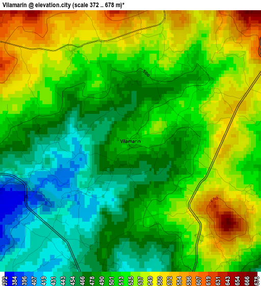
Below is the Elevation map of Vilamarín, which displays elevation range with different colors. Scale of the first map is from 372 to 678 m (1220 to 2224 ft) with average elevation of 506.1 meters (=1660 ft) [note 1]
These maps also provides idea of topography and contour of this city, they are displayed at different zoom levels. More info about maps, scale and edge coordinates you can find below images.
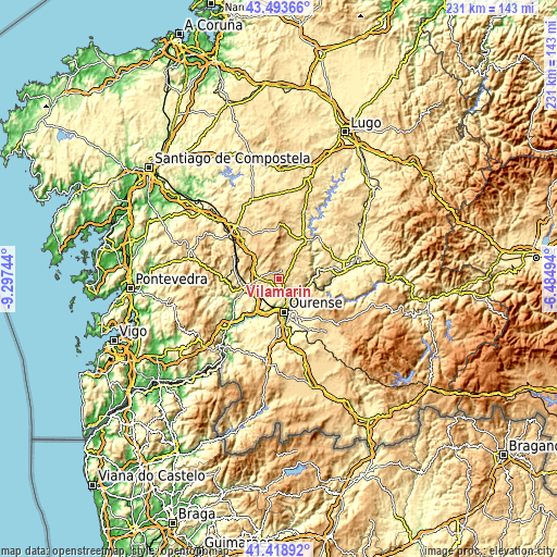
| \ | Map #1 | Topo.Map |
| Scale [m] | 372..678 m | × |
| Scale [ft] | 1220..2224 ft | × |
| Average | 506.1 m = 1660 ft | × |
| Width | 7.21 km = 4.5 mi | 230.7 km = 143.4 mi |
| Height | 7.21 km = 4.5 mi | 230.7 km = 143.4 mi |
| ↑Max Latitude | 42.49729° | 43.49366° |
| Latitude at center | 42.46488° | 42.46488° |
| ↓Min Latitude | 42.432454° | 41.41892° |
| ← Min Longitude | -7.935135° | -9.29744° |
| Longitude center | -7.89119° | -7.89119° |
| →Max Longitude | -7.847245° | -6.48494° |
Nearby cities:
Cities around Vilamarín sort by population:
• Ourense elevation 146 m
14.4 km,  171°
171°
• Pereiro de Aguiar 327 m
15.3 km,  150°
150°
• Coles 341 m
8.6 km, 146°
• Maside 372 m
12.6 km,  241°
241°
• Cea 518 m
8 km,  278°
278°
• Nogueira de Ramuín 572 m
12.8 km,  114°
114°
• Amoeiro 415 m
7.2 km,  221°
221°
• Luintra 637 m
14.8 km, 114°
• Punxín 307 m
14.3 km, 223°
• Piñor 547 m
9.9 km,  294°
294°
• Carballedo 575 m
8.2 km,  39°
39°
• Vilarnaz 393 m
7.5 km,  162°
162°
Multilingual:
 En español:
Vilamarín elevación 509 m.
 En France:
Vilamarín élévation 509 m.
 Auf Deutsch:
Vilamarín höhe über dem Meeresspiegel ist 509 m.

Sources and notes:
- [note 1] Map square and city borders are not equal. Map elevation data is calculated only from area inside that square.
- [src 1] Elevation data from geonames database provided with same terms of usage.
- [src 2] The elevation map of Vilamarín is generated using elevation data from NASA's 3 arcsec (90m) resolution SRTM data.
- [src 3] Base (background) map © OpenStreetMap contributors tiles are generated by Geofabrik and OpenTopoMap.
Copyright & License:
This Vilamarín Elevation Map is licensed under CC BY-SA. You may reuse any part from this page, if you give a proper credit by linking to this URL:
 More info on terms of use page.