Punxín elevation
Punxín (Galicia, Provincia de Ourense), Spain elevation is 307 meters and Punxín elevation in feet is 1007 ft above sea level [src 1]. Punxín is a seat of a third-order administrative division (feature code) with elevation that is 296 meters (971 ft) smaller than average city elevation in Spain.
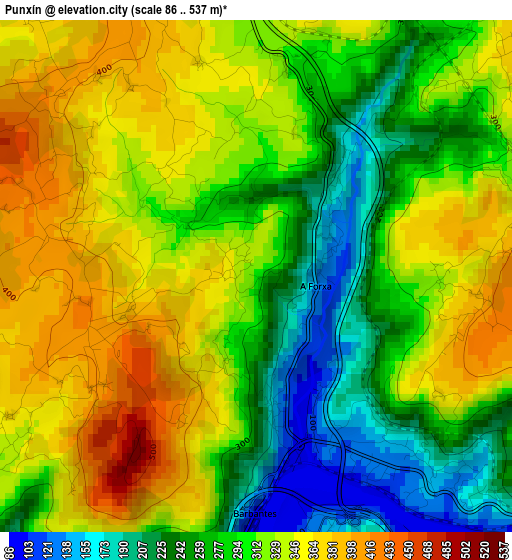
Below is the Elevation map of Punxín, which displays elevation range with different colors. Scale of the first map is from 86 to 537 m (282 to 1762 ft) with average elevation of 308.6 meters (=1012 ft) [note 1]
These maps also provides idea of topography and contour of this city, they are displayed at different zoom levels. More info about maps, scale and edge coordinates you can find below images.
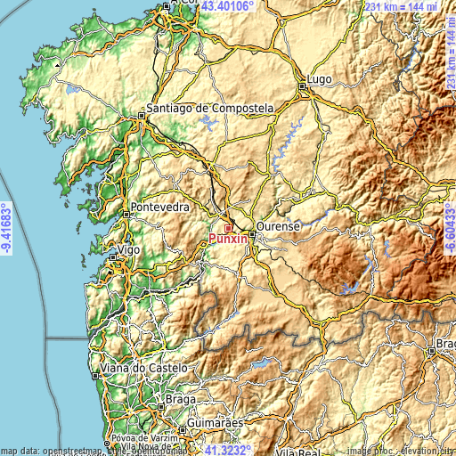
| \ | Map #1 | Topo.Map |
| Scale [m] | 86..537 m | × |
| Scale [ft] | 282..1762 ft | × |
| Average | 308.6 m = 1012 ft | × |
| Width | 7.22 km = 4.5 mi | 231 km = 143.5 mi |
| Height | 7.22 km = 4.5 mi | 231 km = 143.5 mi |
| ↑Max Latitude | 42.403178° | 43.40106° |
| Latitude at center | 42.37072° | 42.37072° |
| ↓Min Latitude | 42.338245° | 41.3232° |
| ← Min Longitude | -8.054525° | -9.41683° |
| Longitude center | -8.01058° | -8.01058° |
| →Max Longitude | -7.966635° | -6.60433° |
Nearby cities:
Cities around Punxín sort by population:
• Ourense elevation 146 m
12.6 km,  107°
107°
• O Carballiño 402 m
8.8 km,  320°
320°
• Boborás 429 m
13 km,  302°
302°
• Maside 372 m
4.6 km,  344°
344°
• Cea 518 m
11.7 km,  9°
9°
• Toén 369 m
7.5 km,  141°
141°
• Amoeiro 415 m
7.1 km,  44°
44°
• Castrelo de Miño 218 m
9.3 km,  209°
209°
• Cenlle 408 m
7.3 km,  243°
243°
• San Amaro 488 m
5.2 km,  273°
273°
• Beade 145 m
10.7 km,  245°
245°
• Vilarnaz 393 m
12.6 km,  74°
74°
Multilingual:
 En español:
Punxín elevación 307 m.
 En France:
Punxín élévation 307 m.


Sources and notes:
- [note 1] Map square and city borders are not equal. Map elevation data is calculated only from area inside that square.
- [src 1] Elevation data from geonames database provided with same terms of usage.
- [src 2] The elevation map of Punxín is generated using elevation data from NASA's 3 arcsec (90m) resolution SRTM data.
- [src 3] Base (background) map © OpenStreetMap contributors tiles are generated by Geofabrik and OpenTopoMap.
Copyright & License:
This Punxín Elevation Map is licensed under CC BY-SA. You may reuse any part from this page, if you give a proper credit by linking to this URL:
 More info on terms of use page.