Garcirrey elevation
Garcirrey (Castille and León, Provincia de Salamanca), Spain elevation is 811 meters and Garcirrey elevation in feet is 2661 ft above sea level [src 1]. Garcirrey is a seat of a third-order administrative division (feature code) with elevation that is 208 meters (682 ft) bigger than average city elevation in Spain.
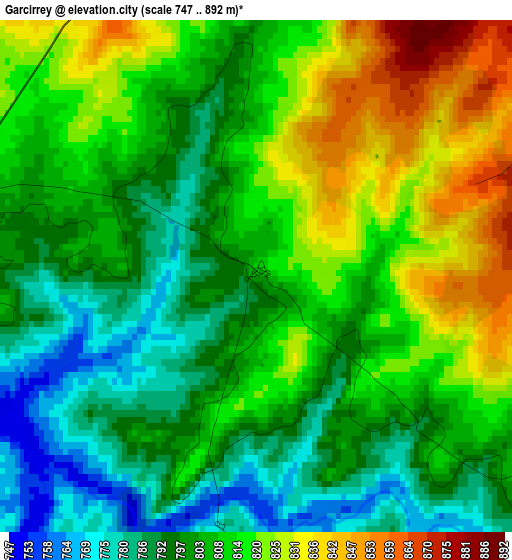
Below is the Elevation map of Garcirrey, which displays elevation range with different colors. Scale of the first map is from 747 to 892 m (2451 to 2927 ft) with average elevation of 807.4 meters (=2649 ft) [note 1]
These maps also provides idea of topography and contour of this city, they are displayed at different zoom levels. More info about maps, scale and edge coordinates you can find below images.
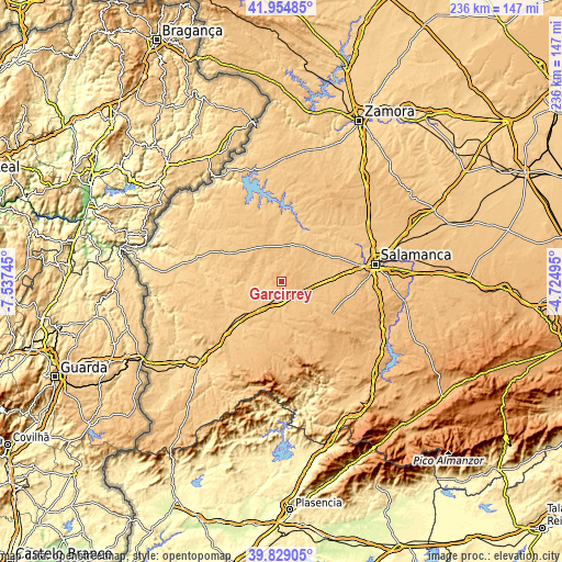
| \ | Map #1 | Topo.Map |
| Scale [m] | 747..892 m | × |
| Scale [ft] | 2451..2927 ft | × |
| Average | 807.4 m = 2649 ft | × |
| Width | 7.39 km = 4.6 mi | 236.4 km = 146.9 mi |
| Height | 7.39 km = 4.6 mi | 236.4 km = 146.9 mi |
| ↑Max Latitude | 40.933698° | 41.95485° |
| Latitude at center | 40.90049° | 40.90049° |
| ↓Min Latitude | 40.867266° | 39.82905° |
| ← Min Longitude | -6.175145° | -7.53745° |
| Longitude center | -6.1312° | -6.1312° |
| →Max Longitude | -6.087255° | -4.72495° |
Nearby cities:
Cities around Garcirrey sort by population:
• Cipérez elevation 767 m
13.2 km,  301°
301°
• Aldehuela de la Bóveda 784 m
8.6 km,  129°
129°
• San Muñoz 782 m
13 km,  178°
178°
• Sando 839 m
7.7 km,  12°
12°
• Robliza de Cojos 818 m
13.4 km,  105°
105°
• Pelarrodríguez 756 m
7 km,  257°
257°
• Santa María de Sando 825 m
8.7 km,  1°
1°
• Buenamadre 757 m
11.1 km,  244°
244°
• Encina de San Silvestre 803 m
13.1 km, 14°
• Tabera de Abajo 813 m
10.9 km,  84°
84°
• Doñinos de Ledesma 847 m
14.9 km,  33°
33°
• Villasdardo 812 m
11.9 km,  346°
346°
Multilingual:
 En español:
Garcirrey elevación 811 m.
 En France:
Garcirrey élévation 811 m.
 Auf Deutsch:
Garcirrey höhe über dem Meeresspiegel ist 811 m.

Sources and notes:
- [note 1] Map square and city borders are not equal. Map elevation data is calculated only from area inside that square.
- [src 1] Elevation data from geonames database provided with same terms of usage.
- [src 2] The elevation map of Garcirrey is generated using elevation data from NASA's 3 arcsec (90m) resolution SRTM data.
- [src 3] Base (background) map © OpenStreetMap contributors tiles are generated by Geofabrik and OpenTopoMap.
Copyright & License:
This Garcirrey Elevation Map is licensed under CC BY-SA. You may reuse any part from this page, if you give a proper credit by linking to this URL:
 More info on terms of use page.