Sando elevation
Sando (Castille and León, Provincia de Salamanca), Spain elevation is 839 meters and Sando elevation in feet is 2753 ft above sea level [src 1]. Sando is a seat of a third-order administrative division (feature code) with elevation that is 236 meters (774 ft) bigger than average city elevation in Spain.
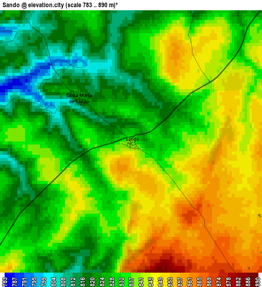
Below is the Elevation map of Sando, which displays elevation range with different colors. Scale of the first map is from 783 to 890 m (2569 to 2920 ft) with average elevation of 834.6 meters (=2738 ft) [note 1]
These maps also provides idea of topography and contour of this city, they are displayed at different zoom levels. More info about maps, scale and edge coordinates you can find below images.
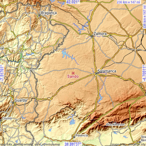
| \ | Map #1 | Topo.Map |
| Scale [m] | 783..890 m | × |
| Scale [ft] | 2569..2920 ft | × |
| Average | 834.6 m = 2738 ft | × |
| Width | 7.38 km = 4.6 mi | 236.1 km = 146.7 mi |
| Height | 7.38 km = 4.6 mi | 236.1 km = 146.7 mi |
| ↑Max Latitude | 41.000904° | 42.021° |
| Latitude at center | 40.96773° | 40.96773° |
| ↓Min Latitude | 40.934539° | 39.89737° |
| ← Min Longitude | -6.155305° | -7.51761° |
| Longitude center | -6.11136° | -6.11136° |
| →Max Longitude | -6.067415° | -4.70511° |
Nearby cities:
Cities around Sando sort by population:
• Cipérez elevation 767 m
13 km,  267°
267°
• Villar de Peralonso 821 m
11.8 km,  307°
307°
• Villarmayor 828 m
12.9 km,  65°
65°
• Villaseco de los Gamitos 834 m
7.6 km,  358°
358°
• Pelarrodríguez 756 m
12.4 km,  223°
223°
• Santa María de Sando 825 m
1.9 km, 310°
• Encina de San Silvestre 803 m
5.4 km,  16°
16°
• Tabera de Abajo 813 m
11.2 km,  124°
124°
• Doñinos de Ledesma 847 m
8.2 km,  52°
52°
• Garcirrey 811 m
7.7 km,  192°
192°
• Gejuelo del Barro 807 m
12.1 km, 355°
• Villasdardo 812 m
6 km, 313°
Multilingual:
 En español:
Sando elevación 839 m.
 En France:
Sando élévation 839 m.


Sources and notes:
- [note 1] Map square and city borders are not equal. Map elevation data is calculated only from area inside that square.
- [src 1] Elevation data from geonames database provided with same terms of usage.
- [src 2] The elevation map of Sando is generated using elevation data from NASA's 3 arcsec (90m) resolution SRTM data.
- [src 3] Base (background) map © OpenStreetMap contributors tiles are generated by Geofabrik and OpenTopoMap.
Copyright & License:
This Sando Elevation Map is licensed under CC BY-SA. You may reuse any part from this page, if you give a proper credit by linking to this URL:
 More info on terms of use page.