Cipérez elevation
Cipérez (Castille and León, Provincia de Salamanca), Spain elevation is 767 meters and Cipérez elevation in feet is 2516 ft above sea level [src 1]. Cipérez is a seat of a third-order administrative division (feature code) with elevation that is 164 meters (538 ft) bigger than average city elevation in Spain.
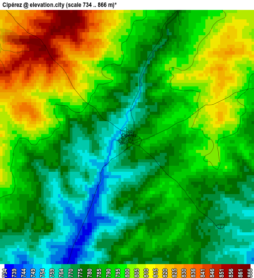
Below is the Elevation map of Cipérez, which displays elevation range with different colors. Scale of the first map is from 734 to 866 m (2408 to 2841 ft) with average elevation of 790.1 meters (=2592 ft) [note 1]
These maps also provides idea of topography and contour of this city, they are displayed at different zoom levels. More info about maps, scale and edge coordinates you can find below images.
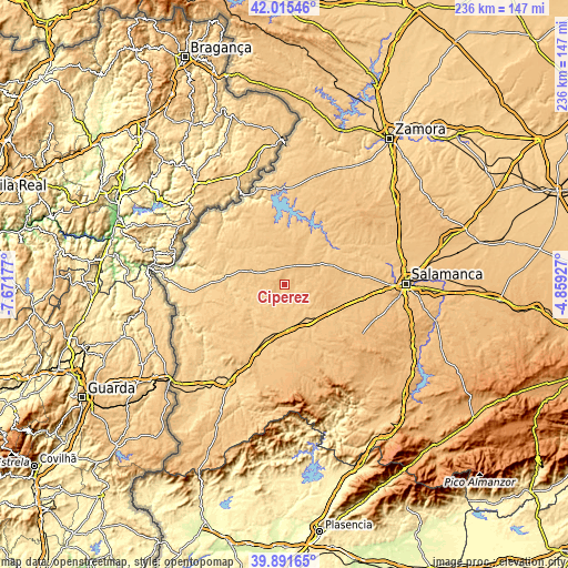
| \ | Map #1 | Topo.Map |
| Scale [m] | 734..866 m | × |
| Scale [ft] | 2408..2841 ft | × |
| Average | 790.1 m = 2592 ft | × |
| Width | 7.38 km = 4.6 mi | 236.1 km = 146.7 mi |
| Height | 7.38 km = 4.6 mi | 236.1 km = 146.7 mi |
| ↑Max Latitude | 40.995277° | 42.01546° |
| Latitude at center | 40.9621° | 40.9621° |
| ↓Min Latitude | 40.928907° | 39.89165° |
| ← Min Longitude | -6.309465° | -7.67177° |
| Longitude center | -6.26552° | -6.26552° |
| →Max Longitude | -6.221575° | -4.85927° |
Nearby cities:
Cities around Cipérez sort by population:
• Villar de Peralonso elevation 821 m
8.6 km,  24°
24°
• Sando 839 m
13 km,  87°
87°
• Pelarrodríguez 756 m
9.4 km,  151°
151°
• Peralejos de Abajo 778 m
9.4 km,  300°
300°
• Santa María de Sando 825 m
11.6 km,  80°
80°
• Buenamadre 757 m
11.8 km,  173°
173°
• Garcirrey 811 m
13.2 km,  121°
121°
• Pozos de Hinojo 735 m
13.4 km,  246°
246°
• Peralejos de Arriba 789 m
7.4 km,  309°
309°
• Villarmuerto 764 m
13.3 km,  322°
322°
• Espadaña 787 m
11.1 km,  351°
351°
• Villasdardo 812 m
9.8 km,  61°
61°
Multilingual:
 En español:
Cipérez elevación 767 m.
 En France:
Cipérez élévation 767 m.


Sources and notes:
- [note 1] Map square and city borders are not equal. Map elevation data is calculated only from area inside that square.
- [src 1] Elevation data from geonames database provided with same terms of usage.
- [src 2] The elevation map of Cipérez is generated using elevation data from NASA's 3 arcsec (90m) resolution SRTM data.
- [src 3] Base (background) map © OpenStreetMap contributors tiles are generated by Geofabrik and OpenTopoMap.
Copyright & License:
This Cipérez Elevation Map is licensed under CC BY-SA. You may reuse any part from this page, if you give a proper credit by linking to this URL:
 More info on terms of use page.