Villarmayor elevation
Villarmayor (Castille and León, Provincia de Salamanca), Spain elevation is 828 meters and Villarmayor elevation in feet is 2717 ft above sea level [src 1]. Villarmayor is a seat of a third-order administrative division (feature code) with elevation that is 225 meters (738 ft) bigger than average city elevation in Spain.
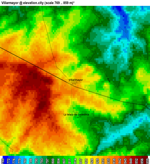
Below is the Elevation map of Villarmayor, which displays elevation range with different colors. Scale of the first map is from 769 to 859 m (2523 to 2818 ft) with average elevation of 815.7 meters (=2676 ft) [note 1]
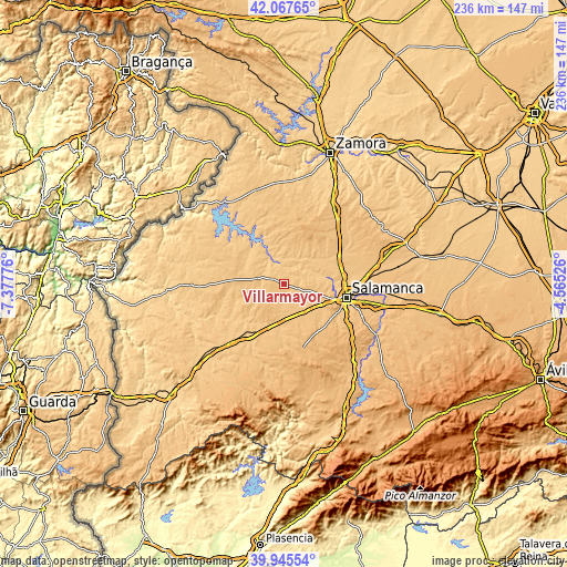
These maps also provides idea of topography and contour of this city, they are displayed at different zoom levels. More info about maps, scale and edge coordinates you can find below images.
| \ | Map #1 | Topo.Map |
| Scale [m] | 769..859 m | × |
| Scale [ft] | 2523..2818 ft | × |
| Average | 815.7 m = 2676 ft | × |
| Width | 7.37 km = 4.6 mi | 236 km = 146.6 mi |
| Height | 7.37 km = 4.6 mi | 235.9 km = 146.6 mi |
| ↑Max Latitude | 41.04829° | 42.06765° |
| Latitude at center | 41.01514° | 41.01514° |
| ↓Min Latitude | 40.981973° | 39.94554° |
| ← Min Longitude | -6.015455° | -7.37776° |
| Longitude center | -5.97151° | -5.97151° |
| →Max Longitude | -5.927565° | -4.56526° |
Nearby cities:
Cities around Villarmayor sort by population:
• Ledesma elevation 755 m
8.5 km,  342°
342°
• Rollán 799 m
7.4 km,  142°
142°
• Galindo y Perahuy 796 m
11.4 km,  134°
134°
• Vega de Tirados 785 m
7.2 km,  80°
80°
• Juzbado 796 m
11.6 km,  52°
52°
• Golpejas 784 m
5.7 km,  107°
107°
• San Pedro del Valle 789 m
9.5 km, 77°
• Encina de San Silvestre 803 m
10.2 km,  269°
269°
• Zarapicos 784 m
10.9 km, 76°
• Tabera de Abajo 813 m
11.9 km,  192°
192°
• Canillas de Abajo 813 m
10.9 km,  160°
160°
• Doñinos de Ledesma 847 m
5.3 km, 266°
Multilingual:
 En español:
Villarmayor elevación 828 m.
 En France:
Villarmayor élévation 828 m.
 Auf Deutsch:
Villarmayor höhe über dem Meeresspiegel ist 828 m.

Sources and notes:
- [note 1] Map square and city borders are not equal. Map elevation data is calculated only from area inside that square.
- [src 1] Elevation data from geonames database provided with same terms of usage.
- [src 2] The elevation map of Villarmayor is generated using elevation data from NASA's 3 arcsec (90m) resolution SRTM data.
- [src 3] Base (background) map © OpenStreetMap contributors tiles are generated by Geofabrik and OpenTopoMap.
Copyright & License:
This Villarmayor Elevation Map is licensed under CC BY-SA. You may reuse any part from this page, if you give a proper credit by linking to this URL:
 More info on terms of use page.