Canillas de Abajo elevation
Canillas de Abajo (Castille and León, Provincia de Salamanca), Spain elevation is 813 meters and Canillas de Abajo elevation in feet is 2667 ft above sea level [src 1]. Canillas de Abajo is a seat of a third-order administrative division (feature code) with elevation that is 210 meters (689 ft) bigger than average city elevation in Spain.
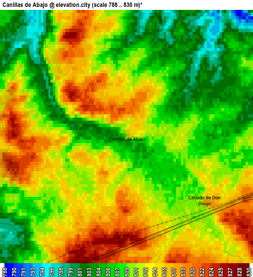
Below is the Elevation map of Canillas de Abajo, which displays elevation range with different colors. Scale of the first map is from 788 to 830 m (2585 to 2723 ft) with average elevation of 810.5 meters (=2659 ft) [note 1]
These maps also provides idea of topography and contour of this city, they are displayed at different zoom levels. More info about maps, scale and edge coordinates you can find below images.
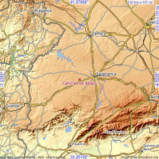
| \ | Map #1 | Topo.Map |
| Scale [m] | 788..830 m | × |
| Scale [ft] | 2585..2723 ft | × |
| Average | 810.5 m = 2659 ft | × |
| Width | 7.38 km = 4.6 mi | 236.3 km = 146.8 mi |
| Height | 7.38 km = 4.6 mi | 236.3 km = 146.8 mi |
| ↑Max Latitude | 40.955856° | 41.97666° |
| Latitude at center | 40.92266° | 40.92266° |
| ↓Min Latitude | 40.889447° | 39.85158° |
| ← Min Longitude | -5.972995° | -7.3353° |
| Longitude center | -5.92905° | -5.92905° |
| →Max Longitude | -5.885105° | -4.5228° |
Nearby cities:
Cities around Canillas de Abajo sort by population:
• Matilla de los Caños del Río elevation 819 m
10.9 km,  186°
186°
• Rollán 799 m
4.5 km,  12°
12°
• Galindo y Perahuy 796 m
5.2 km,  62°
62°
• Aldehuela de la Bóveda 784 m
13.1 km,  232°
232°
• Vega de Tirados 785 m
12 km,  17°
17°
• Parada de Arriba 824 m
13.4 km, 58°
• Robliza de Cojos 818 m
7.4 km,  213°
213°
• Calzada de Don Diego 816 m
3 km,  131°
131°
• Villarmayor 828 m
10.9 km,  340°
340°
• Golpejas 784 m
8.8 km, 12°
• Tabera de Abajo 813 m
6.3 km,  257°
257°
• Doñinos de Ledesma 847 m
13.3 km,  318°
318°
Multilingual:
 En español:
Canillas de Abajo elevación 813 m.
 En France:
Canillas de Abajo élévation 813 m.
 Auf Deutsch:
Canillas de Abajo höhe über dem Meeresspiegel ist 813 m.

Sources and notes:
- [note 1] Map square and city borders are not equal. Map elevation data is calculated only from area inside that square.
- [src 1] Elevation data from geonames database provided with same terms of usage.
- [src 2] The elevation map of Canillas de Abajo is generated using elevation data from NASA's 3 arcsec (90m) resolution SRTM data.
- [src 3] Base (background) map © OpenStreetMap contributors tiles are generated by Geofabrik and OpenTopoMap.
Copyright & License:
This Canillas de Abajo Elevation Map is licensed under CC BY-SA. You may reuse any part from this page, if you give a proper credit by linking to this URL:
 More info on terms of use page.