Juzbado elevation
Juzbado (Castille and León, Provincia de Salamanca), Spain elevation is 796 meters and Juzbado elevation in feet is 2612 ft above sea level [src 1]. Juzbado is a seat of a third-order administrative division (feature code) with elevation that is 193 meters (633 ft) bigger than average city elevation in Spain.
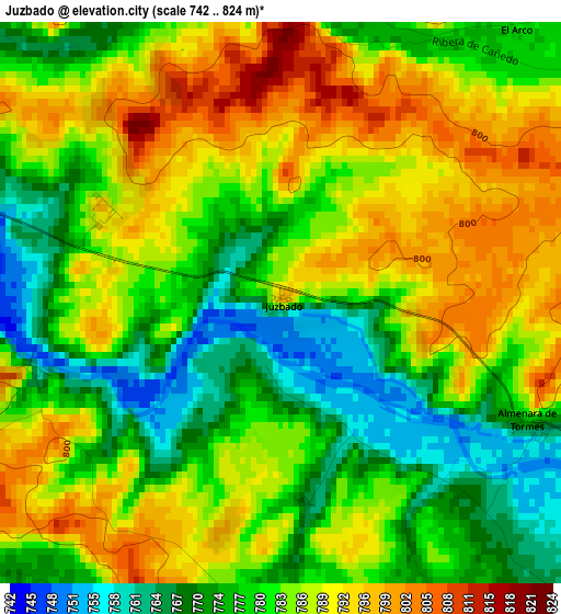
Below is the Elevation map of Juzbado, which displays elevation range with different colors. Scale of the first map is from 742 to 824 m (2434 to 2703 ft) with average elevation of 783 meters (=2569 ft) [note 1]
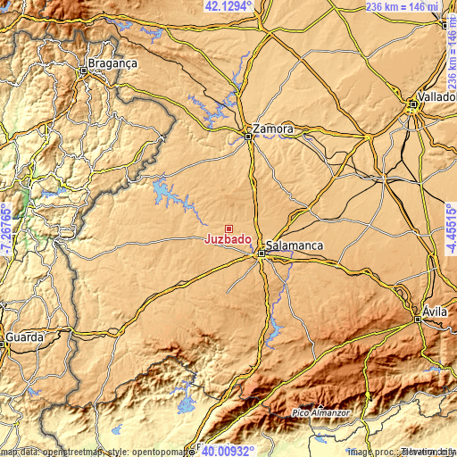
These maps also provides idea of topography and contour of this city, they are displayed at different zoom levels. More info about maps, scale and edge coordinates you can find below images.
| \ | Map #1 | Topo.Map |
| Scale [m] | 742..824 m | × |
| Scale [ft] | 2434..2703 ft | × |
| Average | 783 m = 2569 ft | × |
| Width | 7.37 km = 4.6 mi | 235.7 km = 146.5 mi |
| Height | 7.37 km = 4.6 mi | 235.7 km = 146.5 mi |
| ↑Max Latitude | 41.111028° | 42.1294° |
| Latitude at center | 41.07791° | 41.07791° |
| ↓Min Latitude | 41.044775° | 40.00932° |
| ← Min Longitude | -5.905345° | -7.26765° |
| Longitude center | -5.8614° | -5.8614° |
| →Max Longitude | -5.817455° | -4.45515° |
Nearby cities:
Cities around Juzbado sort by population:
• Valverdón elevation 767 m
8.4 km,  114°
114°
• Vega de Tirados 785 m
6.2 km,  199°
199°
• Almenara de Tormes 782 m
3.5 km,  116°
116°
• Forfoleda 792 m
9.6 km,  76°
76°
• Torresmenudas 790 m
7 km,  66°
66°
• Zamayón 814 m
8.3 km,  18°
18°
• Aldearrodrigo 782 m
5.7 km,  52°
52°
• Golpejas 784 m
9.5 km, 203°
• San Pelayo de Guareña 781 m
4.2 km,  4°
4°
• San Pedro del Valle 789 m
5 km,  178°
178°
• Zarapicos 784 m
4.6 km,  162°
162°
• Añover de Tormes 801 m
8 km,  325°
325°
Multilingual:
 En español:
Juzbado elevación 796 m.
 En France:
Juzbado élévation 796 m.


Sources and notes:
- [note 1] Map square and city borders are not equal. Map elevation data is calculated only from area inside that square.
- [src 1] Elevation data from geonames database provided with same terms of usage.
- [src 2] The elevation map of Juzbado is generated using elevation data from NASA's 3 arcsec (90m) resolution SRTM data.
- [src 3] Base (background) map © OpenStreetMap contributors tiles are generated by Geofabrik and OpenTopoMap.
Copyright & License:
This Juzbado Elevation Map is licensed under CC BY-SA. You may reuse any part from this page, if you give a proper credit by linking to this URL:
 More info on terms of use page.