Valverdón elevation
Valverdón (Castille and León, Provincia de Salamanca), Spain elevation is 767 meters and Valverdón elevation in feet is 2516 ft above sea level [src 1]. Valverdón is a seat of a third-order administrative division (feature code) with elevation that is 164 meters (538 ft) bigger than average city elevation in Spain.
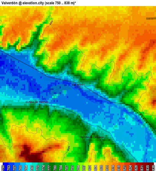
Below is the Elevation map of Valverdón, which displays elevation range with different colors. Scale of the first map is from 750 to 838 m (2461 to 2749 ft) with average elevation of 790.2 meters (=2593 ft) [note 1]
These maps also provides idea of topography and contour of this city, they are displayed at different zoom levels. More info about maps, scale and edge coordinates you can find below images.
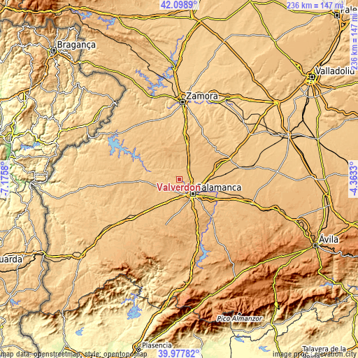
| \ | Map #1 | Topo.Map |
| Scale [m] | 750..838 m | × |
| Scale [ft] | 2461..2749 ft | × |
| Average | 790.2 m = 2593 ft | × |
| Width | 7.37 km = 4.6 mi | 235.8 km = 146.5 mi |
| Height | 7.37 km = 4.6 mi | 235.8 km = 146.5 mi |
| ↑Max Latitude | 41.080044° | 42.0989° |
| Latitude at center | 41.04691° | 41.04691° |
| ↓Min Latitude | 41.013759° | 39.97782° |
| ← Min Longitude | -5.813495° | -7.1758° |
| Longitude center | -5.76955° | -5.76955° |
| →Max Longitude | -5.725605° | -4.3633° |
Nearby cities:
Cities around Valverdón sort by population:
• Villamayor elevation 786 m
8.1 km,  130°
130°
• Calzada de Valdunciel 801 m
7.2 km,  51°
51°
• Castellanos de Villiquera 829 m
6.3 km,  85°
85°
• Carrascal de Barregas 795 m
7.6 km,  175°
175°
• Florida de Liébana 781 m
2.7 km,  167°
167°
• Almenara de Tormes 782 m
4.9 km,  292°
292°
• Parada de Arriba 824 m
7 km,  196°
196°
• Forfoleda 792 m
5.9 km,  16°
16°
• Torresmenudas 790 m
6.3 km,  348°
348°
• Aldearrodrigo 782 m
7.7 km,  335°
335°
• San Pedro del Valle 789 m
7.8 km,  258°
258°
• Zarapicos 784 m
6.4 km, 261°
Multilingual:
 En español:
Valverdón elevación 767 m.
 En France:
Valverdón élévation 767 m.
 Auf Deutsch:
Valverdón höhe über dem Meeresspiegel ist 767 m.

Sources and notes:
- [note 1] Map square and city borders are not equal. Map elevation data is calculated only from area inside that square.
- [src 1] Elevation data from geonames database provided with same terms of usage.
- [src 2] The elevation map of Valverdón is generated using elevation data from NASA's 3 arcsec (90m) resolution SRTM data.
- [src 3] Base (background) map © OpenStreetMap contributors tiles are generated by Geofabrik and OpenTopoMap.
Copyright & License:
This Valverdón Elevation Map is licensed under CC BY-SA. You may reuse any part from this page, if you give a proper credit by linking to this URL:
 More info on terms of use page.