San Muñoz elevation
San Muñoz (Castille and León, Provincia de Salamanca), Spain elevation is 782 meters and San Muñoz elevation in feet is 2566 ft above sea level [src 1]. San Muñoz is a seat of a third-order administrative division (feature code) with elevation that is 179 meters (587 ft) bigger than average city elevation in Spain.
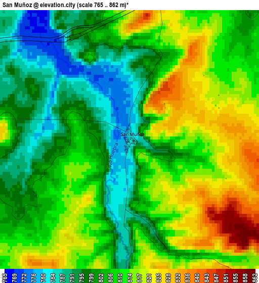
Below is the Elevation map of San Muñoz, which displays elevation range with different colors. Scale of the first map is from 765 to 862 m (2510 to 2828 ft) with average elevation of 807.3 meters (=2649 ft) [note 1]
These maps also provides idea of topography and contour of this city, they are displayed at different zoom levels. More info about maps, scale and edge coordinates you can find below images.
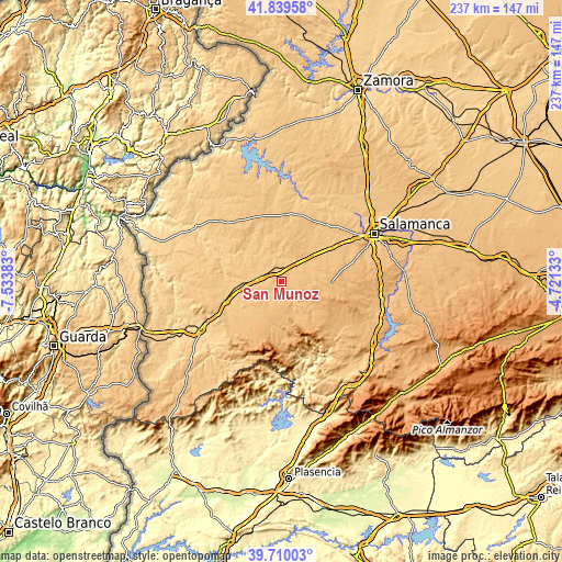
| \ | Map #1 | Topo.Map |
| Scale [m] | 765..862 m | × |
| Scale [ft] | 2510..2828 ft | × |
| Average | 807.3 m = 2649 ft | × |
| Width | 7.4 km = 4.6 mi | 236.8 km = 147.1 mi |
| Height | 7.4 km = 4.6 mi | 236.8 km = 147.1 mi |
| ↑Max Latitude | 40.816606° | 41.83958° |
| Latitude at center | 40.78334° | 40.78334° |
| ↓Min Latitude | 40.750057° | 39.71003° |
| ← Min Longitude | -6.171525° | -7.53383° |
| Longitude center | -6.12758° | -6.12758° |
| →Max Longitude | -6.083635° | -4.72133° |
Nearby cities:
Cities around San Muñoz sort by population:
• La Fuente de San Esteban elevation 770 m
11.2 km,  280°
280°
• Martín de Yeltes 764 m
13.8 km,  266°
266°
• Cabrillas 799 m
6.5 km,  221°
221°
• Aldehuela de la Bóveda 784 m
9.8 km,  40°
40°
• Abusejo 842 m
8.3 km,  187°
187°
• Carrascal del Obispo 897 m
11 km,  101°
101°
• Pelarrodríguez 756 m
13.6 km,  328°
328°
• Villalba de los Llanos 830 m
12.9 km,  81°
81°
• Buenamadre 757 m
13.2 km,  308°
308°
• Berrocal de Huebra 897 m
12.9 km,  123°
123°
• Garcirrey 811 m
13 km,  358°
358°
• Sanchón de la Sagrada 876 m
9.7 km, 117°
Multilingual:
 En español:
San Muñoz elevación 782 m.
 En France:
San Muñoz élévation 782 m.
 Auf Deutsch:
San Muñoz höhe über dem Meeresspiegel ist 782 m.

Sources and notes:
- [note 1] Map square and city borders are not equal. Map elevation data is calculated only from area inside that square.
- [src 1] Elevation data from geonames database provided with same terms of usage.
- [src 2] The elevation map of San Muñoz is generated using elevation data from NASA's 3 arcsec (90m) resolution SRTM data.
- [src 3] Base (background) map © OpenStreetMap contributors tiles are generated by Geofabrik and OpenTopoMap.
Copyright & License:
This San Muñoz Elevation Map is licensed under CC BY-SA. You may reuse any part from this page, if you give a proper credit by linking to this URL:
 More info on terms of use page.