Soria elevation
Soria (Castille and León, Provincia de Soria), Spain elevation is 1064 meters and Soria elevation in feet is 3491 ft above sea level [src 1]. Soria is a seat of a second-order administrative division (feature code) with elevation that is 461 meters (1512 ft) bigger than average city elevation in Spain.
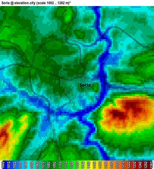
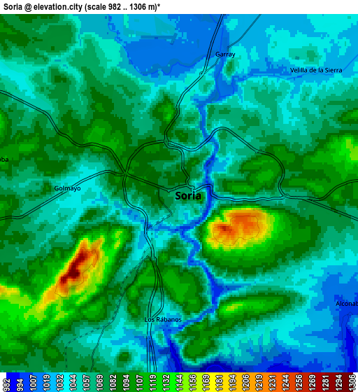
Below is the Elevation map of Soria, which displays elevation range with different colors. Scale of the first map is from 1002 to 1262 m (3287 to 4140 ft) with average elevation of 1081.6 meters (=3549 ft) [note 1]
These maps also provides idea of topography and contour of this city, they are displayed at different zoom levels. More info about maps, scale and edge coordinates you can find below images.
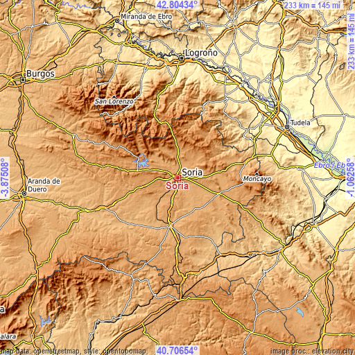
| \ | Map #1 | Map #2 | Topo.Map |
| Scale [m] | 1002..1262 m | 982..1306 m | × |
| Scale [ft] | 3287..4140 ft | 3222..4285 ft | × |
| Average | 1081.6 m = 3549 ft | 1066.7 m = 3500 ft | × |
| Width | 7.29 km = 4.5 mi | 14.58 km = 9.1 mi | 233.3 km = 145 mi |
| Height | 7.29 km = 4.5 mi | 14.58 km = 9.1 mi | 233.2 km = 144.9 mi |
| ↑Max Latitude | 41.79678° | 41.829534° | 42.80434° |
| Latitude at center | 41.76401° | 41.76401° | 41.76401° |
| ↓Min Latitude | 41.731223° | 41.698419° | 40.70654° |
| ← Min Longitude | -2.512775° | -2.556721° | -3.87508° |
| Longitude center | -2.46883° | -2.46883° | -2.46883° |
| →Max Longitude | -2.424885° | -2.380939° | -1.06258° |
Nearby cities:
Cities around Soria sort by population:
• Golmayo elevation 1047 m
4.5 km,  273°
273°
• Garray 1018 m
6.1 km,  18°
18°
• Cidones 1086 m
15.3 km,  291°
291°
• Candilichera 1004 m
15.4 km,  115°
115°
• Almajano 1053 m
14.5 km,  48°
48°
• Alconaba 1008 m
8.3 km, 122°
• Aldealafuente 1008 m
15.7 km,  130°
130°
• Renieblas 1039 m
10.1 km, 52°
• Villaciervos 1182 m
13.1 km, 269°
• Fuentecantos 1033 m
10.1 km, 19°
• Buitrago 1034 m
10.5 km,  28°
28°
• Fuentelsaz de Soria 1079 m
12.2 km, 21°
Multilingual:
 En español:
Soria elevación 1064 m.
 En France:
Soria élévation 1064 m.


Sources and notes:
- [note 1] Map square and city borders are not equal. Map elevation data is calculated only from area inside that square.
- [src 1] Elevation data from geonames database provided with same terms of usage.
- [src 2] The elevation map of Soria is generated using elevation data from NASA's 3 arcsec (90m) resolution SRTM data.
- [src 3] Base (background) map © OpenStreetMap contributors tiles are generated by Geofabrik and OpenTopoMap.
Copyright & License:
This Soria Elevation Map is licensed under CC BY-SA. You may reuse any part from this page, if you give a proper credit by linking to this URL:
 More info on terms of use page.