Golmayo elevation
Golmayo (Castille and León, Provincia de Soria), Spain elevation is 1047 meters and Golmayo elevation in feet is 3435 ft above sea level [src 1]. Golmayo is a seat of a third-order administrative division (feature code) with elevation that is 444 meters (1457 ft) bigger than average city elevation in Spain.
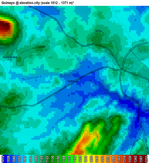
Below is the Elevation map of Golmayo, which displays elevation range with different colors. Scale of the first map is from 1012 to 1371 m (3320 to 4498 ft) with average elevation of 1085.9 meters (=3563 ft) [note 1]
These maps also provides idea of topography and contour of this city, they are displayed at different zoom levels. More info about maps, scale and edge coordinates you can find below images.
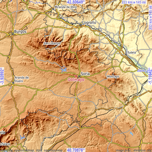
| \ | Map #1 | Topo.Map |
| Scale [m] | 1012..1371 m | × |
| Scale [ft] | 3320..4498 ft | × |
| Average | 1085.9 m = 3563 ft | × |
| Width | 7.29 km = 4.5 mi | 233.2 km = 144.9 mi |
| Height | 7.29 km = 4.5 mi | 233.2 km = 144.9 mi |
| ↑Max Latitude | 41.798969° | 42.80649° |
| Latitude at center | 41.7662° | 41.7662° |
| ↓Min Latitude | 41.733414° | 40.70876° |
| ← Min Longitude | -2.566615° | -3.92892° |
| Longitude center | -2.52267° | -2.52267° |
| →Max Longitude | -2.478725° | -1.11642° |
Nearby cities:
Cities around Golmayo sort by population:
• Soria elevation 1064 m
4.5 km,  93°
93°
• Quintana Redonda 1024 m
16.1 km,  208°
208°
• Garray 1018 m
8.4 km,  48°
48°
• Cidones 1086 m
11.1 km,  298°
298°
• Alconaba 1008 m
12.4 km,  112°
112°
• Renieblas 1039 m
13.8 km,  64°
64°
• Villaciervos 1182 m
8.6 km,  267°
267°
• Fuentecantos 1033 m
12.1 km,  40°
40°
• Buitrago 1034 m
13.1 km, 46°
• Villar del Ala 1147 m
17.1 km,  347°
347°
• Fuentelsaz de Soria 1079 m
14.2 km, 38°
• Rollamienta 1141 m
17.8 km,  357°
357°
Multilingual:
 En español:
Golmayo elevación 1047 m.
 En France:
Golmayo élévation 1047 m.
 Auf Deutsch:
Golmayo höhe über dem Meeresspiegel ist 1047 m.

Sources and notes:
- [note 1] Map square and city borders are not equal. Map elevation data is calculated only from area inside that square.
- [src 1] Elevation data from geonames database provided with same terms of usage.
- [src 2] The elevation map of Golmayo is generated using elevation data from NASA's 3 arcsec (90m) resolution SRTM data.
- [src 3] Base (background) map © OpenStreetMap contributors tiles are generated by Geofabrik and OpenTopoMap.
Copyright & License:
This Golmayo Elevation Map is licensed under CC BY-SA. You may reuse any part from this page, if you give a proper credit by linking to this URL:
 More info on terms of use page.