Garray elevation
Garray (Castille and León, Provincia de Soria), Spain elevation is 1018 meters and Garray elevation in feet is 3340 ft above sea level [src 1]. Garray is a seat of a third-order administrative division (feature code) with elevation that is 415 meters (1362 ft) bigger than average city elevation in Spain.
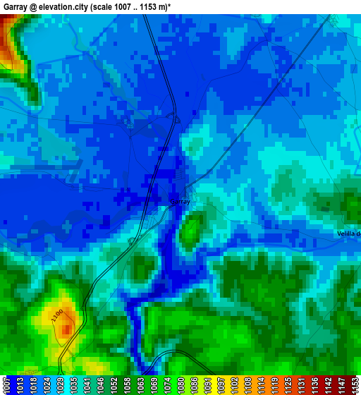
Below is the Elevation map of Garray, which displays elevation range with different colors. Scale of the first map is from 1007 to 1153 m (3304 to 3783 ft) with average elevation of 1034.5 meters (=3394 ft) [note 1]
These maps also provides idea of topography and contour of this city, they are displayed at different zoom levels. More info about maps, scale and edge coordinates you can find below images.
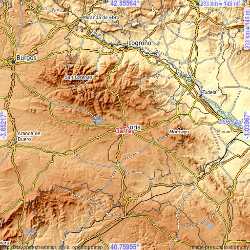
| \ | Map #1 | Topo.Map |
| Scale [m] | 1007..1153 m | × |
| Scale [ft] | 3304..3783 ft | × |
| Average | 1034.5 m = 3394 ft | × |
| Width | 7.28 km = 4.5 mi | 233.1 km = 144.8 mi |
| Height | 7.28 km = 4.5 mi | 233.1 km = 144.8 mi |
| ↑Max Latitude | 41.848914° | 42.85564° |
| Latitude at center | 41.81617° | 41.81617° |
| ↓Min Latitude | 41.78341° | 40.75955° |
| ← Min Longitude | -2.489865° | -3.85217° |
| Longitude center | -2.44592° | -2.44592° |
| →Max Longitude | -2.401975° | -1.03967° |
Nearby cities:
Cities around Garray sort by population:
• Soria elevation 1064 m
6.1 km,  198°
198°
• Golmayo 1047 m
8.4 km,  228°
228°
• Almajano 1053 m
9.7 km,  66°
66°
• Alconaba 1008 m
11.5 km,  153°
153°
• Renieblas 1039 m
6.1 km,  85°
85°
• Ausejo de la Sierra 1099 m
10.6 km,  34°
34°
• Fuentecantos 1033 m
4 km,  21°
21°
• Buitrago 1034 m
4.6 km,  41°
41°
• Narros 1114 m
13.1 km, 73°
• Fuentelsaz de Soria 1079 m
6.1 km, 24°
• Aldealseñor 1091 m
12.8 km,  57°
57°
• Cirujales del Río 1069 m
11.5 km, 60°
Multilingual:
 En español:
Garray elevación 1018 m.
 En France:
Garray élévation 1018 m.


Sources and notes:
- [note 1] Map square and city borders are not equal. Map elevation data is calculated only from area inside that square.
- [src 1] Elevation data from geonames database provided with same terms of usage.
- [src 2] The elevation map of Garray is generated using elevation data from NASA's 3 arcsec (90m) resolution SRTM data.
- [src 3] Base (background) map © OpenStreetMap contributors tiles are generated by Geofabrik and OpenTopoMap.
Copyright & License:
This Garray Elevation Map is licensed under CC BY-SA. You may reuse any part from this page, if you give a proper credit by linking to this URL:
 More info on terms of use page.