Narros elevation
Narros (Castille and León, Provincia de Soria), Spain elevation is 1114 meters and Narros elevation in feet is 3655 ft above sea level [src 1]. Narros is a seat of a third-order administrative division (feature code) with elevation that is 511 meters (1677 ft) bigger than average city elevation in Spain.
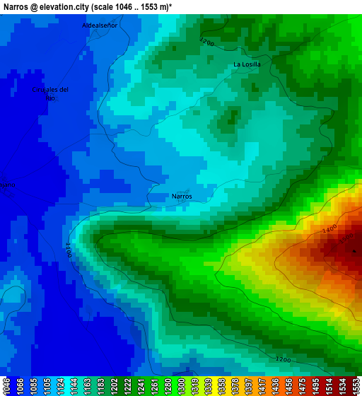
Below is the Elevation map of Narros, which displays elevation range with different colors. Scale of the first map is from 1046 to 1553 m (3432 to 5095 ft) with average elevation of 1169.7 meters (=3838 ft) [note 1]
These maps also provides idea of topography and contour of this city, they are displayed at different zoom levels. More info about maps, scale and edge coordinates you can find below images.
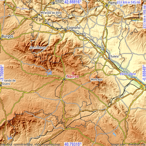
| \ | Map #1 | Topo.Map |
| Scale [m] | 1046..1553 m | × |
| Scale [ft] | 3432..5095 ft | × |
| Average | 1169.7 m = 3838 ft | × |
| Width | 7.28 km = 4.5 mi | 232.9 km = 144.7 mi |
| Height | 7.28 km = 4.5 mi | 232.9 km = 144.7 mi |
| ↑Max Latitude | 41.881957° | 42.88816° |
| Latitude at center | 41.84923° | 41.84923° |
| ↓Min Latitude | 41.816487° | 40.79315° |
| ← Min Longitude | -2.338685° | -3.70099° |
| Longitude center | -2.29474° | -2.29474° |
| →Max Longitude | -2.250795° | -0.88849° |
Nearby cities:
Cities around Narros sort by population:
• Almajano elevation 1053 m
3.6 km,  273°
273°
• Renieblas 1039 m
7.2 km,  243°
243°
• Arancón 1066 m
5.6 km,  168°
168°
• Ausejo de la Sierra 1099 m
8.3 km,  307°
307°
• Buitrago 1034 m
9.4 km, 268°
• Fuentelsaz de Soria 1079 m
10.1 km,  280°
280°
• Aldealseñor 1091 m
3.7 km,  332°
332°
• Cirujales del Río 1069 m
3.2 km, 307°
• Suellacabras 1200 m
5.9 km,  85°
85°
• Castilfrío de la Sierra 1201 m
7.8 km,  353°
353°
• Carrascosa de la Sierra 1186 m
5.3 km,  13°
13°
• Estepa de San Juan 1253 m
9.2 km,  339°
339°
Multilingual:
 En español:
Narros elevación 1114 m.
 En France:
Narros élévation 1114 m.


Sources and notes:
- [note 1] Map square and city borders are not equal. Map elevation data is calculated only from area inside that square.
- [src 1] Elevation data from geonames database provided with same terms of usage.
- [src 2] The elevation map of Narros is generated using elevation data from NASA's 3 arcsec (90m) resolution SRTM data.
- [src 3] Base (background) map © OpenStreetMap contributors tiles are generated by Geofabrik and OpenTopoMap.
Copyright & License:
This Narros Elevation Map is licensed under CC BY-SA. You may reuse any part from this page, if you give a proper credit by linking to this URL:
 More info on terms of use page.