Cidones elevation
Cidones (Castille and León, Provincia de Soria), Spain elevation is 1086 meters and Cidones elevation in feet is 3563 ft above sea level [src 1]. Cidones is a seat of a third-order administrative division (feature code) with elevation that is 483 meters (1585 ft) bigger than average city elevation in Spain.
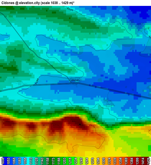
Below is the Elevation map of Cidones, which displays elevation range with different colors. Scale of the first map is from 1038 to 1429 m (3406 to 4688 ft) with average elevation of 1150.8 meters (=3776 ft) [note 1]
These maps also provides idea of topography and contour of this city, they are displayed at different zoom levels. More info about maps, scale and edge coordinates you can find below images.
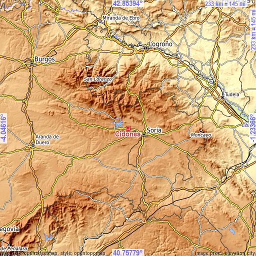
| \ | Map #1 | Topo.Map |
| Scale [m] | 1038..1429 m | × |
| Scale [ft] | 3406..4688 ft | × |
| Average | 1150.8 m = 3776 ft | × |
| Width | 7.28 km = 4.5 mi | 233.1 km = 144.8 mi |
| Height | 7.28 km = 4.5 mi | 233.1 km = 144.8 mi |
| ↑Max Latitude | 41.847184° | 42.85394° |
| Latitude at center | 41.81444° | 41.81444° |
| ↓Min Latitude | 41.781679° | 40.75779° |
| ← Min Longitude | -2.683855° | -4.04616° |
| Longitude center | -2.63991° | -2.63991° |
| →Max Longitude | -2.595965° | -1.23366° |
Nearby cities:
Cities around Cidones sort by population:
• Soria elevation 1064 m
15.3 km,  111°
111°
• Golmayo 1047 m
11.1 km,  118°
118°
• Vinuesa 1113 m
14.9 km,  315°
315°
• Garray 1018 m
16.1 km,  89°
89°
• Abejar 1141 m
12 km,  266°
266°
• Sotillo del Rincón 1108 m
13.4 km,  13°
13°
• Valdeavellano de Tera 1136 m
15.2 km,  20°
20°
• Salduero 1100 m
15.4 km,  302°
302°
• Molinos de Duero 1101 m
14.5 km, 303°
• Villaciervos 1182 m
5.9 km,  169°
169°
• Villar del Ala 1147 m
12.9 km,  28°
28°
• Rollamienta 1141 m
15.3 km,  35°
35°
Multilingual:
 En español:
Cidones elevación 1086 m.
 En France:
Cidones élévation 1086 m.
 Auf Deutsch:
Cidones höhe über dem Meeresspiegel ist 1086 m.

Sources and notes:
- [note 1] Map square and city borders are not equal. Map elevation data is calculated only from area inside that square.
- [src 1] Elevation data from geonames database provided with same terms of usage.
- [src 2] The elevation map of Cidones is generated using elevation data from NASA's 3 arcsec (90m) resolution SRTM data.
- [src 3] Base (background) map © OpenStreetMap contributors tiles are generated by Geofabrik and OpenTopoMap.
Copyright & License:
This Cidones Elevation Map is licensed under CC BY-SA. You may reuse any part from this page, if you give a proper credit by linking to this URL:
 More info on terms of use page.