Aldealafuente elevation
Aldealafuente (Castille and León, Provincia de Soria), Spain elevation is 1008 meters and Aldealafuente elevation in feet is 3307 ft above sea level [src 1]. Aldealafuente is a seat of a third-order administrative division (feature code) with elevation that is 405 meters (1329 ft) bigger than average city elevation in Spain.
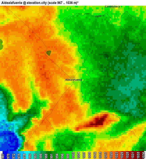
Below is the Elevation map of Aldealafuente, which displays elevation range with different colors. Scale of the first map is from 967 to 1036 m (3173 to 3399 ft) with average elevation of 1003.2 meters (=3291 ft) [note 1]
These maps also provides idea of topography and contour of this city, they are displayed at different zoom levels. More info about maps, scale and edge coordinates you can find below images.
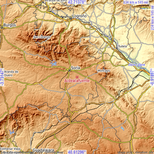
| \ | Map #1 | Topo.Map |
| Scale [m] | 967..1036 m | × |
| Scale [ft] | 3173..3399 ft | × |
| Average | 1003.2 m = 3291 ft | × |
| Width | 7.3 km = 4.5 mi | 233.6 km = 145.2 mi |
| Height | 7.3 km = 4.5 mi | 233.6 km = 145.2 mi |
| ↑Max Latitude | 41.704757° | 42.71378° |
| Latitude at center | 41.67194° | 41.67194° |
| ↓Min Latitude | 41.639106° | 40.61296° |
| ← Min Longitude | -2.369165° | -3.73147° |
| Longitude center | -2.32522° | -2.32522° |
| →Max Longitude | -2.281275° | -0.91897° |
Nearby cities:
Cities around Aldealafuente sort by population:
• Gómara elevation 1052 m
9.9 km,  122°
122°
• Almenar de Soria 1020 m
10.4 km,  83°
83°
• Cubo de la Solana 993 m
11.2 km,  225°
225°
• Candilichera 1004 m
4.1 km,  28°
28°
• Tejado 989 m
10.4 km,  152°
152°
• Alconaba 1008 m
7.6 km,  319°
319°
• Arancón 1066 m
14.7 km,  14°
14°
• Cabrejas del Campo 992 m
4.7 km, 77°
• Borjabad 1011 m
13.7 km,  194°
194°
• Buberos 1019 m
11.2 km,  104°
104°
• Villaseca de Arciel 1007 m
14.6 km,  111°
111°
• Aliud 1011 m
6.3 km, 108°
Multilingual:
 En español:
Aldealafuente elevación 1008 m.
 En France:
Aldealafuente élévation 1008 m.
 Auf Deutsch:
Aldealafuente höhe über dem Meeresspiegel ist 1008 m.

Sources and notes:
- [note 1] Map square and city borders are not equal. Map elevation data is calculated only from area inside that square.
- [src 1] Elevation data from geonames database provided with same terms of usage.
- [src 2] The elevation map of Aldealafuente is generated using elevation data from NASA's 3 arcsec (90m) resolution SRTM data.
- [src 3] Base (background) map © OpenStreetMap contributors tiles are generated by Geofabrik and OpenTopoMap.
Copyright & License:
This Aldealafuente Elevation Map is licensed under CC BY-SA. You may reuse any part from this page, if you give a proper credit by linking to this URL:
 More info on terms of use page.