El Viso del Alcor elevation
El Viso del Alcor (Andalusia, Provincia de Sevilla), Spain elevation is 167 meters and El Viso del Alcor elevation in feet is 548 ft above sea level [src 1]. El Viso del Alcor is a populated place (feature code) with elevation that is 436 meters (1430 ft) smaller than average city elevation in Spain.
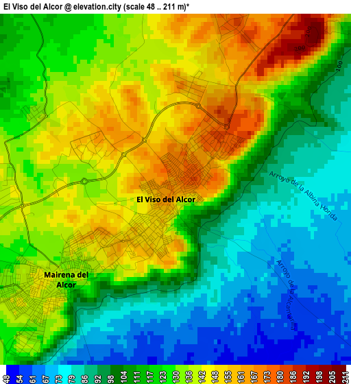
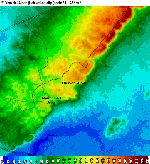
Below is the Elevation map of El Viso del Alcor, which displays elevation range with different colors. Scale of the first map is from 48 to 211 m (157 to 692 ft) with average elevation of 118.3 meters (=388 ft) [note 1]
These maps also provides idea of topography and contour of this city, they are displayed at different zoom levels. More info about maps, scale and edge coordinates you can find below images.
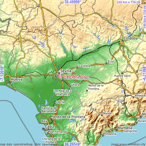
| \ | Map #1 | Map #2 | Topo.Map |
| Scale [m] | 48..211 m | 31..232 m | × |
| Scale [ft] | 157..692 ft | 102..761 ft | × |
| Average | 118.3 m = 388 ft | 97.9 m = 321 ft | × |
| Width | 7.76 km = 4.8 mi | 15.53 km = 9.6 mi | 248.5 km = 154.4 mi |
| Height | 7.76 km = 4.8 mi | 15.53 km = 9.6 mi | 248.5 km = 154.4 mi |
| ↑Max Latitude | 37.425967° | 37.460857° | 38.49998° |
| Latitude at center | 37.39106° | 37.39106° | 37.39106° |
| ↓Min Latitude | 37.356137° | 37.321198° | 36.26549° |
| ← Min Longitude | -5.763875° | -5.807821° | -7.12618° |
| Longitude center | -5.71993° | -5.71993° | -5.71993° |
| →Max Longitude | -5.675985° | -5.632039° | -4.31368° |
Nearby cities:
Cities around El Viso del Alcor sort by population:
• Sevilla elevation 16 m
22.4 km,  267°
267°
• Dos Hermanas 45 m
21.5 km,  235°
235°
• Alcalá de Guadaira 71 m
12.1 km, 240°
• Utrera 52 m
23.5 km,  193°
193°
• Carmona 221 m
11 km,  36°
36°
• Mairena del Alcor 135 m
3.3 km,  232°
232°
• El Arahal 118 m
21 km,  132°
132°
• Brenes 21 m
22.1 km,  322°
322°
• Tocina 29 m
24.3 km,  357°
357°
• Paradas 120 m
22.7 km,  119°
119°
• Alcolea del Río 36 m
25.3 km,  10°
10°
• Valdezorras 24 m
18.7 km,  283°
283°
Multilingual:
 En español:
El Viso del Alcor elevación 167 m.
 En France:
El Viso del Alcor élévation 167 m.
 Auf Deutsch:
El Viso del Alcor höhe über dem Meeresspiegel ist 167 m.

Sources and notes:
- [note 1] Map square and city borders are not equal. Map elevation data is calculated only from area inside that square.
- [src 1] Elevation data from geonames database provided with same terms of usage.
- [src 2] The elevation map of El Viso del Alcor is generated using elevation data from NASA's 3 arcsec (90m) resolution SRTM data.
- [src 3] Base (background) map © OpenStreetMap contributors tiles are generated by Geofabrik and OpenTopoMap.
Copyright & License:
This El Viso del Alcor Elevation Map is licensed under CC BY-SA. You may reuse any part from this page, if you give a proper credit by linking to this URL:
 More info on terms of use page.