Partaloa elevation
Partaloa (Andalusia, Almería), Spain elevation is 540 meters and Partaloa elevation in feet is 1772 ft above sea level [src 1]. Partaloa is a seat of a third-order administrative division (feature code) with elevation that is 63 meters (207 ft) smaller than average city elevation in Spain.
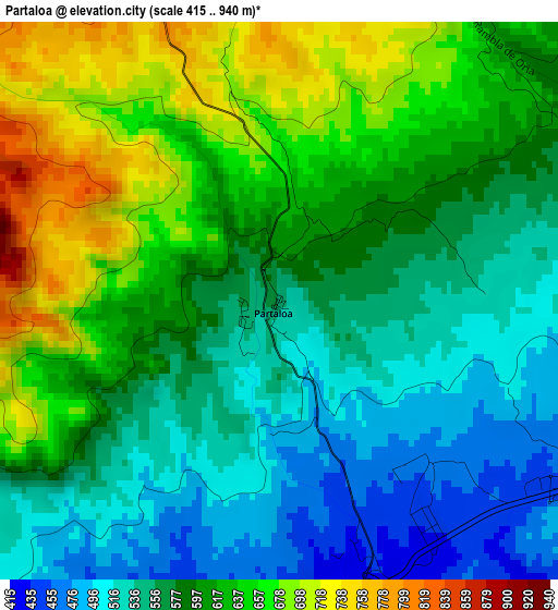
Below is the Elevation map of Partaloa, which displays elevation range with different colors. Scale of the first map is from 415 to 940 m (1362 to 3084 ft) with average elevation of 593.2 meters (=1946 ft) [note 1]
These maps also provides idea of topography and contour of this city, they are displayed at different zoom levels. More info about maps, scale and edge coordinates you can find below images.
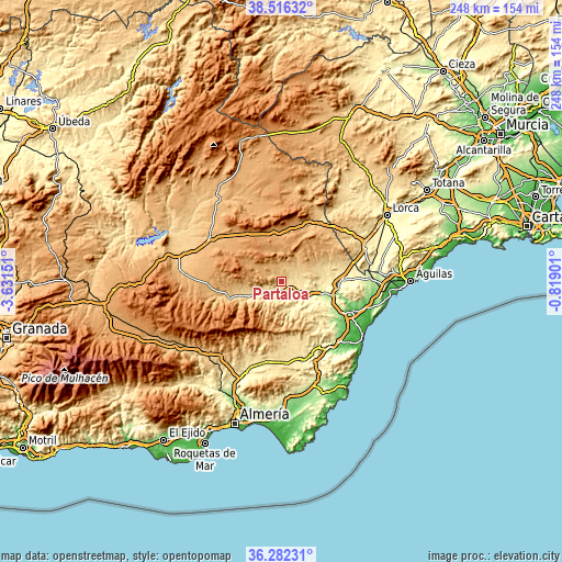
| \ | Map #1 | Topo.Map |
| Scale [m] | 415..940 m | × |
| Scale [ft] | 1362..3084 ft | × |
| Average | 593.2 m = 1946 ft | × |
| Width | 7.76 km = 4.8 mi | 248.4 km = 154.3 mi |
| Height | 7.76 km = 4.8 mi | 248.4 km = 154.3 mi |
| ↑Max Latitude | 37.442539° | 38.51632° |
| Latitude at center | 37.40764° | 37.40764° |
| ↓Min Latitude | 37.372725° | 36.28231° |
| ← Min Longitude | -2.269205° | -3.63151° |
| Longitude center | -2.22526° | -2.22526° |
| →Max Longitude | -2.181315° | -0.81901° |
Nearby cities:
Cities around Partaloa sort by population:
• Albox elevation 428 m
7 km,  107°
107°
• Olula del Río 488 m
8.7 km,  227°
227°
• Macael 589 m
10.6 km,  218°
218°
• Cantoria 380 m
6.9 km,  154°
154°
• Arboleas 296 m
14.8 km,  115°
115°
• Oria 1028 m
10.5 km,  325°
325°
• Fines 476 m
6 km,  209°
209°
• Purchena 546 m
13.7 km,  240°
240°
• Albánchez 503 m
14.3 km,  164°
164°
• Somontín 821 m
14.5 km,  263°
263°
• Urrácal 749 m
12.4 km, 264°
• Taberno 713 m
14.7 km,  62°
62°
Multilingual:
 En español:
Partaloa elevación 540 m.
 En France:
Partaloa élévation 540 m.
 Auf Deutsch:
Partaloa höhe über dem Meeresspiegel ist 540 m.

Sources and notes:
- [note 1] Map square and city borders are not equal. Map elevation data is calculated only from area inside that square.
- [src 1] Elevation data from geonames database provided with same terms of usage.
- [src 2] The elevation map of Partaloa is generated using elevation data from NASA's 3 arcsec (90m) resolution SRTM data.
- [src 3] Base (background) map © OpenStreetMap contributors tiles are generated by Geofabrik and OpenTopoMap.
Copyright & License:
This Partaloa Elevation Map is licensed under CC BY-SA. You may reuse any part from this page, if you give a proper credit by linking to this URL:
 More info on terms of use page.