Albánchez elevation
Albánchez (Andalusia, Almería), Spain elevation is 503 meters and Albánchez elevation in feet is 1650 ft above sea level [src 1]. Albánchez is a seat of a third-order administrative division (feature code) with elevation that is 100 meters (328 ft) smaller than average city elevation in Spain.
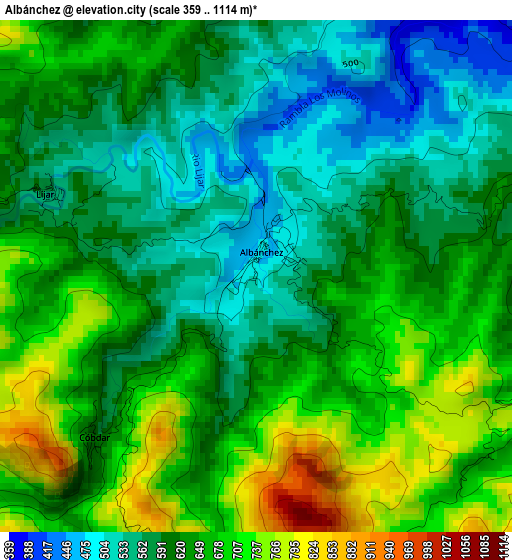
Below is the Elevation map of Albánchez, which displays elevation range with different colors. Scale of the first map is from 359 to 1114 m (1178 to 3655 ft) with average elevation of 628.2 meters (=2061 ft) [note 1]
These maps also provides idea of topography and contour of this city, they are displayed at different zoom levels. More info about maps, scale and edge coordinates you can find below images.
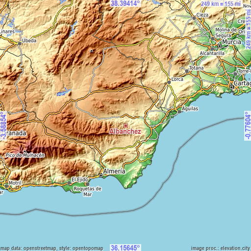
| \ | Map #1 | Topo.Map |
| Scale [m] | 359..1114 m | × |
| Scale [ft] | 1178..3655 ft | × |
| Average | 628.2 m = 2061 ft | × |
| Width | 7.78 km = 4.8 mi | 248.8 km = 154.6 mi |
| Height | 7.78 km = 4.8 mi | 248.8 km = 154.6 mi |
| ↑Max Latitude | 37.318567° | 38.39414° |
| Latitude at center | 37.28361° | 37.28361° |
| ↓Min Latitude | 37.248637° | 36.15645° |
| ← Min Longitude | -2.226235° | -3.58854° |
| Longitude center | -2.18229° | -2.18229° |
| →Max Longitude | -2.138345° | -0.77604° |
Nearby cities:
Cities around Albánchez sort by population:
• Albox elevation 428 m
12 km,  13°
13°
• Macael 589 m
11.8 km,  297°
297°
• Cantoria 380 m
7.6 km,  353°
353°
• Arboleas 296 m
12.1 km,  52°
52°
• Fines 476 m
10.9 km,  321°
321°
• Uleila del Campo 618 m
11.2 km,  190°
190°
• Tahal 1010 m
11 km,  235°
235°
• Benizalón 941 m
9.5 km,  213°
213°
• Chercos 915 m
8.1 km,  246°
246°
• Cóbdar 620 m
3.5 km,  226°
226°
• Alcudia de Monteagud 1028 m
9.2 km, 234°
• Benitagla 952 m
7.7 km,  221°
221°
Multilingual:
 En español:
Albánchez elevación 503 m.
 En France:
Albánchez élévation 503 m.
 Auf Deutsch:
Albánchez höhe über dem Meeresspiegel ist 503 m.

Sources and notes:
- [note 1] Map square and city borders are not equal. Map elevation data is calculated only from area inside that square.
- [src 1] Elevation data from geonames database provided with same terms of usage.
- [src 2] The elevation map of Albánchez is generated using elevation data from NASA's 3 arcsec (90m) resolution SRTM data.
- [src 3] Base (background) map © OpenStreetMap contributors tiles are generated by Geofabrik and OpenTopoMap.
Copyright & License:
This Albánchez Elevation Map is licensed under CC BY-SA. You may reuse any part from this page, if you give a proper credit by linking to this URL:
 More info on terms of use page.