Purchena elevation
Purchena (Andalusia, Almería), Spain elevation is 546 meters and Purchena elevation in feet is 1791 ft above sea level [src 1]. Purchena is a seat of a third-order administrative division (feature code) with elevation that is 57 meters (187 ft) smaller than average city elevation in Spain.
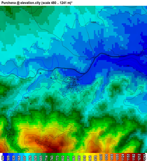
Below is the Elevation map of Purchena, which displays elevation range with different colors. Scale of the first map is from 480 to 1241 m (1575 to 4072 ft) with average elevation of 669 meters (=2195 ft) [note 1]
These maps also provides idea of topography and contour of this city, they are displayed at different zoom levels. More info about maps, scale and edge coordinates you can find below images.
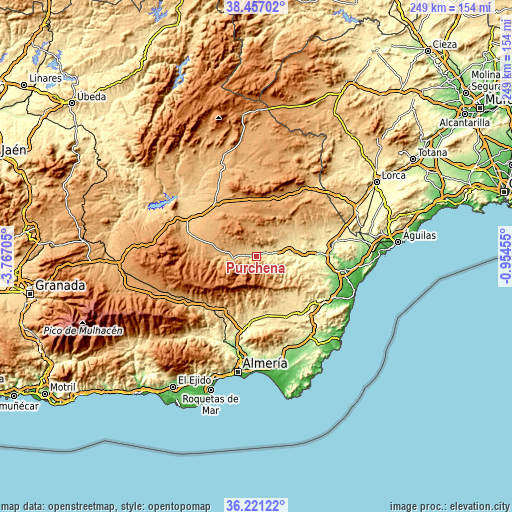
| \ | Map #1 | Topo.Map |
| Scale [m] | 480..1241 m | × |
| Scale [ft] | 1575..4072 ft | × |
| Average | 669 m = 2195 ft | × |
| Width | 7.77 km = 4.8 mi | 248.6 km = 154.5 mi |
| Height | 7.77 km = 4.8 mi | 248.6 km = 154.5 mi |
| ↑Max Latitude | 37.382367° | 38.45702° |
| Latitude at center | 37.34744° | 37.34744° |
| ↓Min Latitude | 37.312497° | 36.22122° |
| ← Min Longitude | -2.404745° | -3.76705° |
| Longitude center | -2.3608° | -2.3608° |
| →Max Longitude | -2.316855° | -0.95455° |
Nearby cities:
Cities around Purchena sort by population:
• La Mojonera elevation 1106 m
9.1 km,  227°
227°
• Olula del Río 488 m
5.6 km,  82°
82°
• Macael 589 m
5.5 km,  106°
106°
• Tíjola 689 m
6.4 km,  268°
268°
• Lúcar 889 m
8.2 km,  316°
316°
• Somontín 821 m
5.5 km,  333°
333°
• Sierro 726 m
4.3 km, 230°
• Urrácal 749 m
5.6 km,  356°
356°
• Armuña de Almanzora 629 m
4.5 km, 274°
• Bayarque 817 m
6.9 km,  254°
254°
• Suflí 640 m
2.6 km, 248°
• Laroya 1009 m
6 km,  156°
156°
Multilingual:
 En español:
Purchena elevación 546 m.
 En France:
Purchena élévation 546 m.
 Auf Deutsch:
Purchena höhe über dem Meeresspiegel ist 546 m.

Sources and notes:
- [note 1] Map square and city borders are not equal. Map elevation data is calculated only from area inside that square.
- [src 1] Elevation data from geonames database provided with same terms of usage.
- [src 2] The elevation map of Purchena is generated using elevation data from NASA's 3 arcsec (90m) resolution SRTM data.
- [src 3] Base (background) map © OpenStreetMap contributors tiles are generated by Geofabrik and OpenTopoMap.
Copyright & License:
This Purchena Elevation Map is licensed under CC BY-SA. You may reuse any part from this page, if you give a proper credit by linking to this URL:
 More info on terms of use page.