Laroya elevation
Laroya (Andalusia, Almería), Spain elevation is 1009 meters and Laroya elevation in feet is 3310 ft above sea level [src 1]. Laroya is a seat of a third-order administrative division (feature code) with elevation that is 406 meters (1332 ft) bigger than average city elevation in Spain.
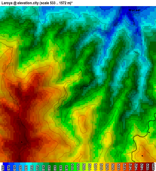
Below is the Elevation map of Laroya, which displays elevation range with different colors. Scale of the first map is from 533 to 1572 m (1749 to 5157 ft) with average elevation of 1020.4 meters (=3348 ft) [note 1]
These maps also provides idea of topography and contour of this city, they are displayed at different zoom levels. More info about maps, scale and edge coordinates you can find below images.
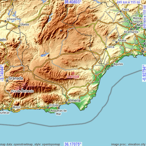
| \ | Map #1 | Topo.Map |
| Scale [m] | 533..1572 m | × |
| Scale [ft] | 1749..5157 ft | × |
| Average | 1020.4 m = 3348 ft | × |
| Width | 7.77 km = 4.8 mi | 248.8 km = 154.6 mi |
| Height | 7.77 km = 4.8 mi | 248.8 km = 154.6 mi |
| ↑Max Latitude | 37.33266° | 38.40803° |
| Latitude at center | 37.29771° | 37.29771° |
| ↓Min Latitude | 37.262743° | 36.17075° |
| ← Min Longitude | -2.378135° | -3.74044° |
| Longitude center | -2.33419° | -2.33419° |
| →Max Longitude | -2.290245° | -0.92794° |
Nearby cities:
Cities around Laroya sort by population:
• La Mojonera elevation 1106 m
9.1 km,  266°
266°
• Olula del Río 488 m
7.1 km,  27°
27°
• Macael 589 m
4.9 km,  36°
36°
• Fines 476 m
9.7 km, 43°
• Purchena 546 m
6 km,  336°
336°
• Sierro 726 m
6.3 km,  295°
295°
• Tahal 1010 m
8.9 km,  150°
150°
• Armuña de Almanzora 629 m
9 km,  310°
310°
• Chercos 915 m
7.7 km,  128°
128°
• Bayarque 817 m
9.7 km,  292°
292°
• Suflí 640 m
6.6 km, 313°
• Alcudia de Monteagud 1028 m
9.2 km,  139°
139°
Multilingual:
 En español:
Laroya elevación 1009 m.
 En France:
Laroya élévation 1009 m.


Sources and notes:
- [note 1] Map square and city borders are not equal. Map elevation data is calculated only from area inside that square.
- [src 1] Elevation data from geonames database provided with same terms of usage.
- [src 2] The elevation map of Laroya is generated using elevation data from NASA's 3 arcsec (90m) resolution SRTM data.
- [src 3] Base (background) map © OpenStreetMap contributors tiles are generated by Geofabrik and OpenTopoMap.
Copyright & License:
This Laroya Elevation Map is licensed under CC BY-SA. You may reuse any part from this page, if you give a proper credit by linking to this URL:
 More info on terms of use page.