Tíjola elevation
Tíjola (Andalusia, Almería), Spain elevation is 689 meters and Tíjola elevation in feet is 2260 ft above sea level [src 1]. Tíjola is a populated place (feature code) with elevation that is 86 meters (282 ft) bigger than average city elevation in Spain.
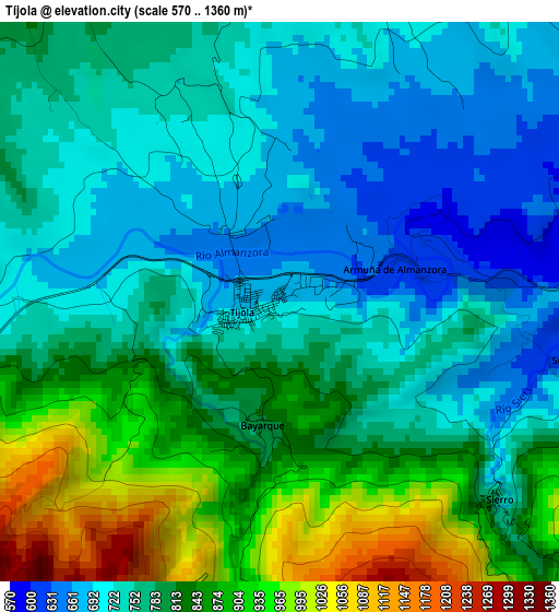
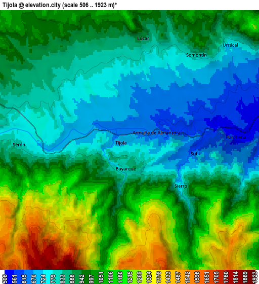
Below is the Elevation map of Tíjola, which displays elevation range with different colors. Scale of the first map is from 570 to 1360 m (1870 to 4462 ft) with average elevation of 788.6 meters (=2587 ft) [note 1]
These maps also provides idea of topography and contour of this city, they are displayed at different zoom levels. More info about maps, scale and edge coordinates you can find below images.
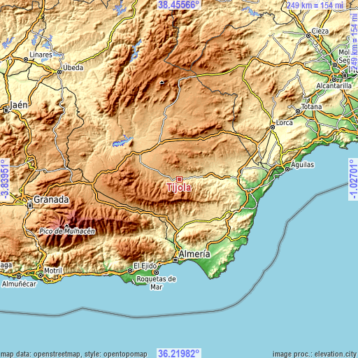
| \ | Map #1 | Map #2 | Topo.Map |
| Scale [m] | 570..1360 m | 506..1923 m | × |
| Scale [ft] | 1870..4462 ft | 1660..6309 ft | × |
| Average | 788.6 m = 2587 ft | 962.5 m = 3158 ft | × |
| Width | 7.77 km = 4.8 mi | 15.54 km = 9.7 mi | 248.6 km = 154.5 mi |
| Height | 7.77 km = 4.8 mi | 15.54 km = 9.7 mi | 248.6 km = 154.5 mi |
| ↑Max Latitude | 37.380988° | 37.415899° | 38.45566° |
| Latitude at center | 37.34606° | 37.34606° | 37.34606° |
| ↓Min Latitude | 37.311116° | 37.276156° | 36.21982° |
| ← Min Longitude | -2.477205° | -2.521151° | -3.83951° |
| Longitude center | -2.43326° | -2.43326° | -2.43326° |
| →Max Longitude | -2.389315° | -2.345369° | -1.02701° |
Nearby cities:
Cities around Tíjola sort by population:
• La Mojonera elevation 1106 m
6 km,  183°
183°
• Macael 589 m
11.8 km,  96°
96°
• Serón 793 m
6.7 km,  268°
268°
• Purchena 546 m
6.4 km,  88°
88°
• Lúcar 889 m
6.1 km,  6°
6°
• Somontín 821 m
6.5 km,  38°
38°
• Sierro 726 m
4.1 km,  130°
130°
• Urrácal 749 m
8.3 km,  46°
46°
• Armuña de Almanzora 629 m
2 km,  76°
76°
• Bayarque 817 m
1.7 km,  188°
188°
• Suflí 640 m
4.1 km, 101°
• Laroya 1009 m
10.3 km,  121°
121°
Multilingual:
 En español:
Tíjola elevación 689 m.
 En France:
Tíjola élévation 689 m.


Sources and notes:
- [note 1] Map square and city borders are not equal. Map elevation data is calculated only from area inside that square.
- [src 1] Elevation data from geonames database provided with same terms of usage.
- [src 2] The elevation map of Tíjola is generated using elevation data from NASA's 3 arcsec (90m) resolution SRTM data.
- [src 3] Base (background) map © OpenStreetMap contributors tiles are generated by Geofabrik and OpenTopoMap.
Copyright & License:
This Tíjola Elevation Map is licensed under CC BY-SA. You may reuse any part from this page, if you give a proper credit by linking to this URL:
 More info on terms of use page.