Dahlen elevation
Dahlen (Saxony), Germany elevation is 146 meters and Dahlen elevation in feet is 479 ft above sea level [src 1]. Dahlen is a populated place (feature code) with elevation that is 112 meters (367 ft) smaller than average city elevation in Germany.
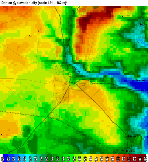
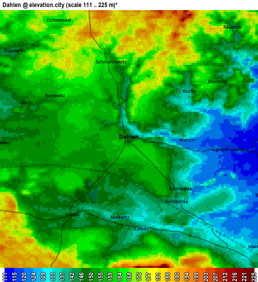
Below is the Elevation map of Dahlen, which displays elevation range with different colors. Scale of the first map is from 121 to 182 m (397 to 597 ft) with average elevation of 151.8 meters (=498 ft) [note 1]
These maps also provides idea of topography and contour of this city, they are displayed at different zoom levels. More info about maps, scale and edge coordinates you can find below images.
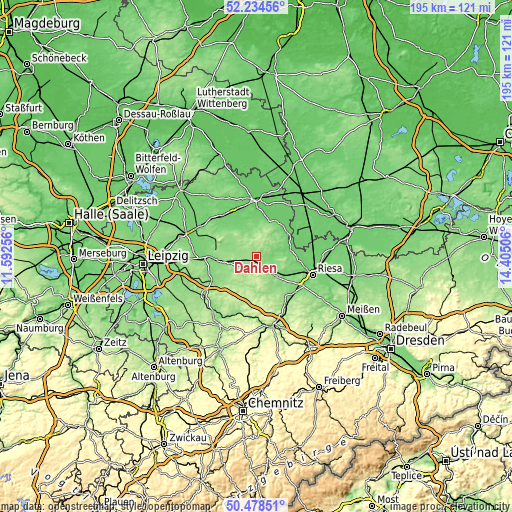
| \ | Map #1 | Map #2 | Topo.Map |
| Scale [m] | 121..182 m | 111..225 m | × |
| Scale [ft] | 397..597 ft | 364..738 ft | × |
| Average | 151.8 m = 498 ft | 154.2 m = 506 ft | × |
| Width | 6.1 km = 3.8 mi | 12.2 km = 7.6 mi | 195.3 km = 121.4 mi |
| Height | 6.1 km = 3.8 mi | 12.2 km = 7.6 mi | 195.2 km = 121.3 mi |
| ↑Max Latitude | 51.392379° | 51.419792° | 52.23456° |
| Latitude at center | 51.36495° | 51.36495° | 51.36495° |
| ↓Min Latitude | 51.337504° | 51.310042° | 50.47851° |
| ← Min Longitude | 12.954865° | 12.910919° | 11.59256° |
| Longitude center | 12.99881° | 12.99881° | 12.99881° |
| →Max Longitude | 13.042755° | 13.086701° | 14.40506° |
Nearby cities:
Cities around Dahlen sort by population:
• Oschatz elevation 124 m
10.6 km,  133°
133°
• Wermsdorf 179 m
9.7 km,  200°
200°
• Belgern 113 m
15.7 km,  33°
33°
• Mügeln 150 m
14.7 km,  167°
167°
• Mühlberg 93 m
17.3 km,  63°
63°
• Strehla 118 m
15.9 km,  95°
95°
• Falkenhain 135 m
9.6 km,  293°
293°
• Schildau 119 m
11.3 km,  335°
335°
• Hohburg 127 m
14.4 km, 291°
• Naundorf 137 m
14.2 km,  147°
147°
• Cavertitz 101 m
9.6 km,  77°
77°
• Mutzschen 189 m
13.7 km,  213°
213°
Multilingual:
 En español:
Dahlen elevación 146 m.
 En France:
Dahlen élévation 146 m.


Sources and notes:
- [note 1] Map square and city borders are not equal. Map elevation data is calculated only from area inside that square.
- [src 1] Elevation data from geonames database provided with same terms of usage.
- [src 2] The elevation map of Dahlen is generated using elevation data from NASA's 3 arcsec (90m) resolution SRTM data.
- [src 3] Base (background) map © OpenStreetMap contributors tiles are generated by Geofabrik and OpenTopoMap.
Copyright & License:
This Dahlen Elevation Map is licensed under CC BY-SA. You may reuse any part from this page, if you give a proper credit by linking to this URL:
 More info on terms of use page.