Wermsdorf elevation
Wermsdorf (Saxony), Germany elevation is 179 meters and Wermsdorf elevation in feet is 587 ft above sea level [src 1]. Wermsdorf is a seat of a fourth-order administrative division (feature code) with elevation that is 79 meters (259 ft) smaller than average city elevation in Germany.
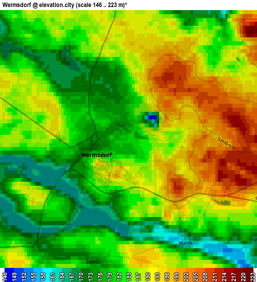
Below is the Elevation map of Wermsdorf, which displays elevation range with different colors. Scale of the first map is from 146 to 223 m (479 to 732 ft) with average elevation of 185.5 meters (=609 ft) [note 1]
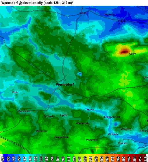
These maps also provides idea of topography and contour of this city, they are displayed at different zoom levels. More info about maps, scale and edge coordinates you can find below images.
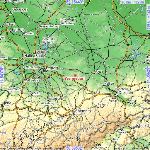
| \ | Map #1 | Map #2 | Topo.Map |
| Scale [m] | 146..223 m | 128..319 m | × |
| Scale [ft] | 479..732 ft | 420..1047 ft | × |
| Average | 185.5 m = 609 ft | 183.8 m = 603 ft | × |
| Width | 6.11 km = 3.8 mi | 12.22 km = 7.6 mi | 195.6 km = 121.5 mi |
| Height | 6.11 km = 3.8 mi | 12.22 km = 7.6 mi | 195.6 km = 121.5 mi |
| ↑Max Latitude | 51.310808° | 51.33827° | 52.15449° |
| Latitude at center | 51.28333° | 51.28333° | 51.28333° |
| ↓Min Latitude | 51.255835° | 51.228324° | 50.39532° |
| ← Min Longitude | 12.906055° | 12.862109° | 11.54375° |
| Longitude center | 12.95° | 12.95° | 12.95° |
| →Max Longitude | 12.993945° | 13.037891° | 14.35625° |
Nearby cities:
Cities around Wermsdorf sort by population:
• Oschatz elevation 124 m
11.3 km,  80°
80°
• Leisnig 221 m
14.1 km,  186°
186°
• Dahlen 146 m
9.7 km,  20°
20°
• Mügeln 150 m
8.5 km,  128°
128°
• Ostrau 184 m
9.7 km,  208°
208°
• Trebsen 129 m
13.6 km,  272°
272°
• Nerchau 138 m
11.3 km,  262°
262°
• Falkenhain 135 m
14 km,  336°
336°
• Großweitzschen 256 m
15.4 km,  154°
154°
• Bockelwitz 215 m
9.3 km,  177°
177°
• Naundorf 137 m
11.4 km,  104°
104°
• Mutzschen 189 m
4.7 km,  239°
239°
Multilingual:
 En español:
Wermsdorf elevación 179 m.
 En France:
Wermsdorf élévation 179 m.
 Auf Deutsch:
Wermsdorf höhe über dem Meeresspiegel ist 179 m.

Sources and notes:
- [note 1] Map square and city borders are not equal. Map elevation data is calculated only from area inside that square.
- [src 1] Elevation data from geonames database provided with same terms of usage.
- [src 2] The elevation map of Wermsdorf is generated using elevation data from NASA's 3 arcsec (90m) resolution SRTM data.
- [src 3] Base (background) map © OpenStreetMap contributors tiles are generated by Geofabrik and OpenTopoMap.
Copyright & License:
This Wermsdorf Elevation Map is licensed under CC BY-SA. You may reuse any part from this page, if you give a proper credit by linking to this URL:
 More info on terms of use page.