Dresden elevation
Dresden (Saxony), Germany elevation is 116 meters and Dresden elevation in feet is 381 ft above sea level [src 1]. Dresden is a seat of a first-order administrative division (feature code) with elevation that is 142 meters (466 ft) smaller than average city elevation in Germany.
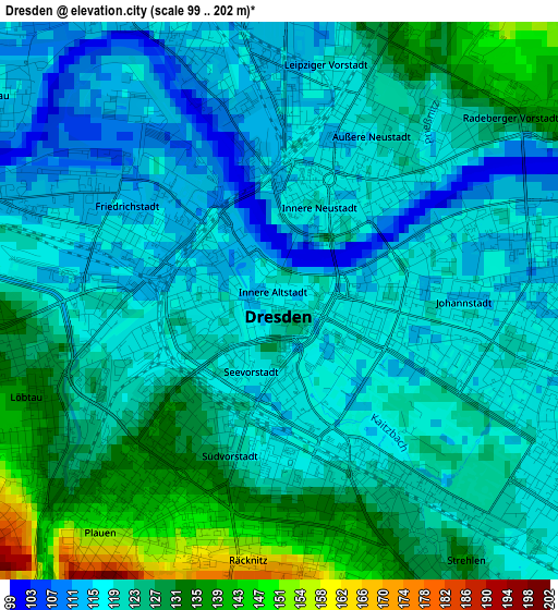
Below is the Elevation map of Dresden, which displays elevation range with different colors. Scale of the first map is from 99 to 202 m (325 to 663 ft) with average elevation of 121.8 meters (=400 ft) [note 1]
These maps also provides idea of topography and contour of this city, they are displayed at different zoom levels. More info about maps, scale and edge coordinates you can find below images.
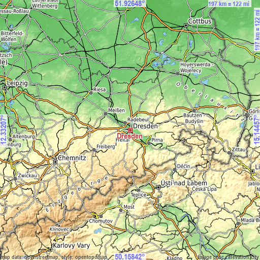
| \ | Map #1 | Map #2 | Topo.Map |
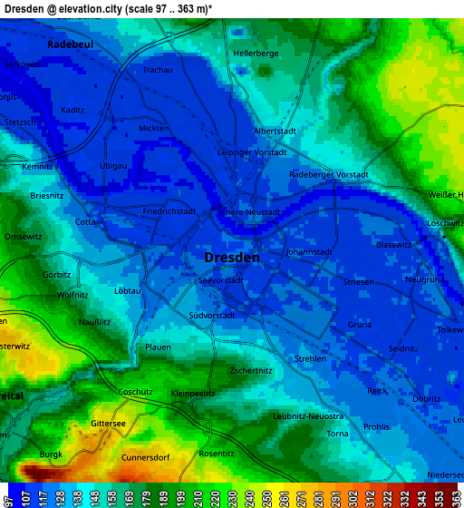
| Scale [m] | 99..202 m | 97..363 m | × |
| Scale [ft] | 325..663 ft | 318..1191 ft | × |
| Average | 121.8 m = 400 ft | 154.5 m = 507 ft | × |
| Width | 6.14 km = 3.8 mi | 12.29 km = 7.6 mi | 196.6 km = 122.2 mi |
| Height | 6.14 km = 3.8 mi | 12.29 km = 7.6 mi | 196.6 km = 122.2 mi |
| ↑Max Latitude | 51.078507° | 51.106108° | 51.92648° |
| Latitude at center | 51.05089° | 51.05089° | 51.05089° |
| ↓Min Latitude | 51.023256° | 50.995606° | 50.15842° |
| ← Min Longitude | 13.694375° | 13.650429° | 12.33207° |
| Longitude center | 13.73832° | 13.73832° | 13.73832° |
| →Max Longitude | 13.782265° | 13.826211° | 15.14457° |
Nearby cities:
Cities around Dresden sort by population:
• Freital elevation 171 m
8.3 km,  228°
228°
• Radebeul 120 m
8.2 km,  318°
318°
• Radeberg 241 m
13.9 km,  61°
61°
• Heidenau 120 m
12.6 km,  134°
134°
• Wilsdruff 269 m
14.1 km,  270°
270°
• Bannewitz 280 m
6.6 km,  192°
192°
• Moritzburg 180 m
12.7 km,  341°
341°
• Dohna 164 m
13.5 km,  141°
141°
• Tharandt 231 m
13.2 km,  236°
236°
• Rabenau 336 m
11.7 km,  214°
214°
• Kreischa 210 m
11.8 km,  174°
174°
• Albertstadt 148 m
4.1 km,  28°
28°
Multilingual:
 En español:
Dresde elevación 116 m.
 En France:
Dresde élévation 116 m.


Sources and notes:
- [note 1] Map square and city borders are not equal. Map elevation data is calculated only from area inside that square.
- [src 1] Elevation data from geonames database provided with same terms of usage.
- [src 2] The elevation map of Dresden is generated using elevation data from NASA's 3 arcsec (90m) resolution SRTM data.
- [src 3] Base (background) map © OpenStreetMap contributors tiles are generated by Geofabrik and OpenTopoMap.
Copyright & License:
This Dresden Elevation Map is licensed under CC BY-SA. You may reuse any part from this page, if you give a proper credit by linking to this URL:
 More info on terms of use page.