Wilsdruff elevation
Wilsdruff (Saxony), Germany elevation is 269 meters and Wilsdruff elevation in feet is 883 ft above sea level [src 1]. Wilsdruff is a populated place (feature code) with elevation that is 11 meters (36 ft) bigger than average city elevation in Germany.
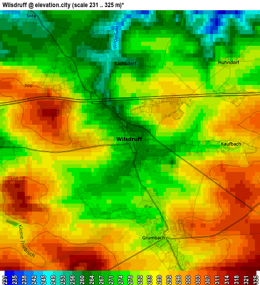
Below is the Elevation map of Wilsdruff, which displays elevation range with different colors. Scale of the first map is from 231 to 325 m (758 to 1066 ft) with average elevation of 283.2 meters (=929 ft) [note 1]
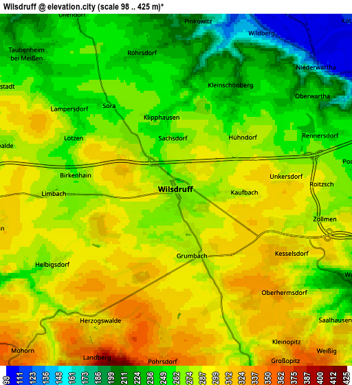
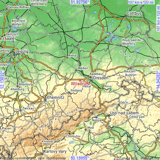
These maps also provides idea of topography and contour of this city, they are displayed at different zoom levels. More info about maps, scale and edge coordinates you can find below images.
| \ | Map #1 | Map #2 | Topo.Map |
| Scale [m] | 231..325 m | 98..425 m | × |
| Scale [ft] | 758..1066 ft | 322..1394 ft | × |
| Average | 283.2 m = 929 ft | 272.2 m = 893 ft | × |
| Width | 6.14 km = 3.8 mi | 12.29 km = 7.6 mi | 196.6 km = 122.2 mi |
| Height | 6.14 km = 3.8 mi | 12.29 km = 7.6 mi | 196.6 km = 122.2 mi |
| ↑Max Latitude | 51.079606° | 51.107206° | 51.92756° |
| Latitude at center | 51.05199° | 51.05199° | 51.05199° |
| ↓Min Latitude | 51.024357° | 50.996708° | 50.15955° |
| ← Min Longitude | 13.492625° | 13.448679° | 12.13032° |
| Longitude center | 13.53657° | 13.53657° | 13.53657° |
| →Max Longitude | 13.580515° | 13.624461° | 14.94282° |
Nearby cities:
Cities around Wilsdruff sort by population:
• Freital elevation 171 m
9.6 km,  125°
125°
• Radebeul 120 m
10.6 km,  54°
54°
• Meissen 109 m
13 km,  340°
340°
• Coswig 116 m
9.5 km,  20°
20°
• Weinböhla 137 m
12.9 km,  9°
9°
• Klipphausen 270 m
2.4 km,  318°
318°
• Tharandt 231 m
8 km,  157°
157°
• Rabenau 336 m
12.2 km,  142°
142°
• Niederau 120 m
13.9 km,  2°
2°
• Reinsberg 278 m
12.9 km,  247°
247°
• Niederschöna 348 m
12.5 km,  220°
220°
• Dorfhain 341 m
13.4 km,  170°
170°
Multilingual:
 En español:
Wilsdruff elevación 269 m.
 En France:
Wilsdruff élévation 269 m.
 Auf Deutsch:
Wilsdruff höhe über dem Meeresspiegel ist 269 m.

Sources and notes:
- [note 1] Map square and city borders are not equal. Map elevation data is calculated only from area inside that square.
- [src 1] Elevation data from geonames database provided with same terms of usage.
- [src 2] The elevation map of Wilsdruff is generated using elevation data from NASA's 3 arcsec (90m) resolution SRTM data.
- [src 3] Base (background) map © OpenStreetMap contributors tiles are generated by Geofabrik and OpenTopoMap.
Copyright & License:
This Wilsdruff Elevation Map is licensed under CC BY-SA. You may reuse any part from this page, if you give a proper credit by linking to this URL:
 More info on terms of use page.