Rabenau elevation
Rabenau (Saxony), Germany elevation is 336 meters and Rabenau elevation in feet is 1102 ft above sea level [src 1]. Rabenau is a populated place (feature code) with elevation that is 78 meters (256 ft) bigger than average city elevation in Germany.
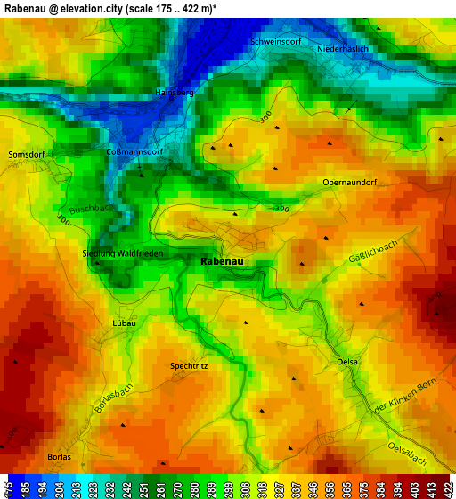
Below is the Elevation map of Rabenau, which displays elevation range with different colors. Scale of the first map is from 175 to 422 m (574 to 1385 ft) with average elevation of 315 meters (=1033 ft) [note 1]
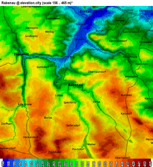
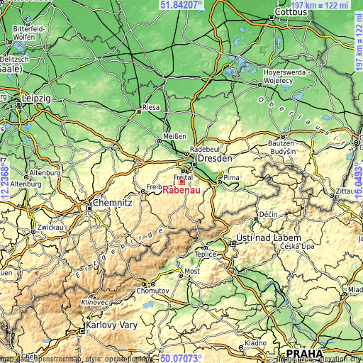
These maps also provides idea of topography and contour of this city, they are displayed at different zoom levels. More info about maps, scale and edge coordinates you can find below images.
| \ | Map #1 | Map #2 | Topo.Map |
| Scale [m] | 175..422 m | 156..465 m | × |
| Scale [ft] | 574..1385 ft | 512..1526 ft | × |
| Average | 315 m = 1033 ft | 321.9 m = 1056 ft | × |
| Width | 6.15 km = 3.8 mi | 12.31 km = 7.6 mi | 197 km = 122.4 mi |
| Height | 6.15 km = 3.8 mi | 12.31 km = 7.6 mi | 196.9 km = 122.3 mi |
| ↑Max Latitude | 50.992508° | 51.02016° | 51.84207° |
| Latitude at center | 50.96484° | 50.96484° | 50.96484° |
| ↓Min Latitude | 50.937155° | 50.909454° | 50.07073° |
| ← Min Longitude | 13.599105° | 13.555159° | 12.2368° |
| Longitude center | 13.64305° | 13.64305° | 13.64305° |
| →Max Longitude | 13.686995° | 13.730941° | 15.0493° |
Nearby cities:
Cities around Rabenau sort by population:
• Dresden elevation 116 m
11.7 km,  34°
34°
• Freital 171 m
4.1 km,  5°
5°
• Wilsdruff 269 m
12.2 km,  322°
322°
• Dippoldiswalde 365 m
7.8 km,  166°
166°
• Bannewitz 280 m
6.1 km,  58°
58°
• Tharandt 231 m
4.9 km,  297°
297°
• Kreischa 210 m
8.1 km,  105°
105°
• Pretzschendorf 475 m
13.1 km,  219°
219°
• Reinhardtsgrimma 328 m
11.2 km,  135°
135°
• Obercunnersdorf 394 m
7.9 km,  227°
227°
• Dorfhain 341 m
6.4 km,  236°
236°
• Hermsdorf 379 m
7.9 km,  125°
125°
Multilingual:
 En español:
Rabenau elevación 336 m.
 En France:
Rabenau élévation 336 m.


Sources and notes:
- [note 1] Map square and city borders are not equal. Map elevation data is calculated only from area inside that square.
- [src 1] Elevation data from geonames database provided with same terms of usage.
- [src 2] The elevation map of Rabenau is generated using elevation data from NASA's 3 arcsec (90m) resolution SRTM data.
- [src 3] Base (background) map © OpenStreetMap contributors tiles are generated by Geofabrik and OpenTopoMap.
Copyright & License:
This Rabenau Elevation Map is licensed under CC BY-SA. You may reuse any part from this page, if you give a proper credit by linking to this URL:
 More info on terms of use page.