Langquaid elevation
Langquaid (Bavaria, Lower Bavaria), Germany elevation is 389 meters and Langquaid elevation in feet is 1276 ft above sea level [src 1]. Langquaid is a populated place (feature code) with elevation that is 131 meters (430 ft) bigger than average city elevation in Germany.
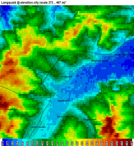
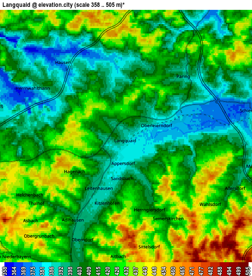
Below is the Elevation map of Langquaid, which displays elevation range with different colors. Scale of the first map is from 373 to 467 m (1224 to 1532 ft) with average elevation of 407.2 meters (=1336 ft) [note 1]
These maps also provides idea of topography and contour of this city, they are displayed at different zoom levels. More info about maps, scale and edge coordinates you can find below images.
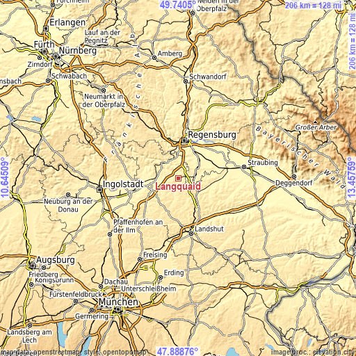
| \ | Map #1 | Map #2 | Topo.Map |
| Scale [m] | 373..467 m | 358..505 m | × |
| Scale [ft] | 1224..1532 ft | 1175..1657 ft | × |
| Average | 407.2 m = 1336 ft | 415.1 m = 1362 ft | × |
| Width | 6.43 km = 4 mi | 12.87 km = 8 mi | 205.9 km = 127.9 mi |
| Height | 6.43 km = 4 mi | 12.87 km = 8 mi | 205.9 km = 127.9 mi |
| ↑Max Latitude | 48.852105° | 48.881012° | 49.7405° |
| Latitude at center | 48.82318° | 48.82318° | 48.82318° |
| ↓Min Latitude | 48.794239° | 48.765281° | 47.88876° |
| ← Min Longitude | 12.007395° | 11.963449° | 10.64509° |
| Longitude center | 12.05134° | 12.05134° | 12.05134° |
| →Max Longitude | 12.095285° | 12.139231° | 13.45759° |
Nearby cities:
Cities around Langquaid sort by population:
• Bad Abbach elevation 355 m
12.7 km,  357°
357°
• Rottenburg an der Laaber 446 m
13.6 km,  187°
187°
• Schierling 379 m
6.6 km,  79°
79°
• Mallersdorf-Pfaffenberg 383 m
14.6 km,  115°
115°
• Saal 348 m
12.3 km,  314°
314°
• Rohr 425 m
8.5 km,  223°
223°
• Thalmassing 355 m
12.4 km,  37°
37°
• Hausen 377 m
5.2 km,  320°
320°
• Pfakofen 360 m
13.5 km,  73°
73°
• Teugn 378 m
8.3 km,  339°
339°
• Biburg 371 m
14.7 km,  255°
255°
• Herrngiersdorf 406 m
4.1 km,  158°
158°
Multilingual:
 En español:
Langquaid elevación 389 m.
 En France:
Langquaid élévation 389 m.
 Auf Deutsch:
Langquaid höhe über dem Meeresspiegel ist 389 m.

Sources and notes:
- [note 1] Map square and city borders are not equal. Map elevation data is calculated only from area inside that square.
- [src 1] Elevation data from geonames database provided with same terms of usage.
- [src 2] The elevation map of Langquaid is generated using elevation data from NASA's 3 arcsec (90m) resolution SRTM data.
- [src 3] Base (background) map © OpenStreetMap contributors tiles are generated by Geofabrik and OpenTopoMap.
Copyright & License:
This Langquaid Elevation Map is licensed under CC BY-SA. You may reuse any part from this page, if you give a proper credit by linking to this URL:
 More info on terms of use page.