Herrngiersdorf elevation
Herrngiersdorf (Bavaria, Lower Bavaria), Germany elevation is 406 meters and Herrngiersdorf elevation in feet is 1332 ft above sea level [src 1]. Herrngiersdorf is a seat of a fourth-order administrative division (feature code) with elevation that is 148 meters (486 ft) bigger than average city elevation in Germany.
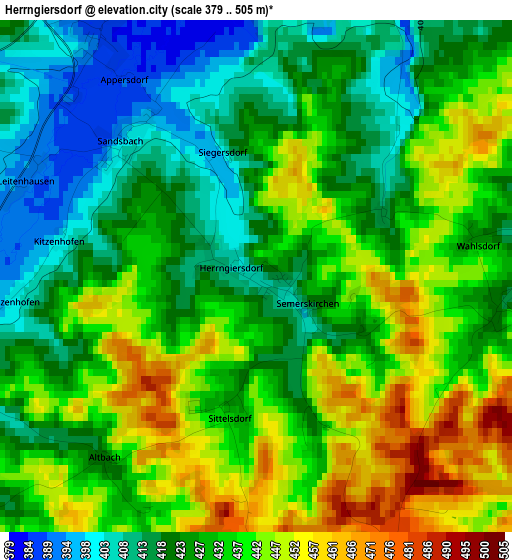
Below is the Elevation map of Herrngiersdorf, which displays elevation range with different colors. Scale of the first map is from 379 to 505 m (1243 to 1657 ft) with average elevation of 430.6 meters (=1413 ft) [note 1]
These maps also provides idea of topography and contour of this city, they are displayed at different zoom levels. More info about maps, scale and edge coordinates you can find below images.
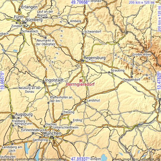
| \ | Map #1 | Topo.Map |
| Scale [m] | 379..505 m | × |
| Scale [ft] | 1243..1657 ft | × |
| Average | 430.6 m = 1413 ft | × |
| Width | 6.44 km = 4 mi | 206 km = 128 mi |
| Height | 6.44 km = 4 mi | 206 km = 128 mi |
| ↑Max Latitude | 48.817575° | 49.70658° |
| Latitude at center | 48.78863° | 48.78863° |
| ↓Min Latitude | 48.759669° | 47.85357° |
| ← Min Longitude | 12.028055° | 10.66575° |
| Longitude center | 12.072° | 12.072° |
| →Max Longitude | 12.115945° | 13.47825° |
Nearby cities:
Cities around Herrngiersdorf sort by population:
• Rottenburg an der Laaber elevation 446 m
10.1 km,  198°
198°
• Ergoldsbach 420 m
14.4 km,  137°
137°
• Schierling 379 m
7.1 km,  44°
44°
• Mallersdorf-Pfaffenberg 383 m
11.9 km,  101°
101°
• Langquaid 389 m
4.1 km,  338°
338°
• Hohenthann 478 m
14.3 km,  173°
173°
• Rohr 425 m
7.7 km,  252°
252°
• Thalmassing 355 m
15 km,  23°
23°
• Hausen 377 m
9.2 km,  328°
328°
• Pfakofen 360 m
13.8 km,  55°
55°
• Teugn 378 m
12.4 km, 339°
• Wildenberg 414 m
14.3 km,  242°
242°
Multilingual:
 En español:
Herrngiersdorf elevación 406 m.
 En France:
Herrngiersdorf élévation 406 m.
 Auf Deutsch:
Herrngiersdorf höhe über dem Meeresspiegel ist 406 m.

Sources and notes:
- [note 1] Map square and city borders are not equal. Map elevation data is calculated only from area inside that square.
- [src 1] Elevation data from geonames database provided with same terms of usage.
- [src 2] The elevation map of Herrngiersdorf is generated using elevation data from NASA's 3 arcsec (90m) resolution SRTM data.
- [src 3] Base (background) map © OpenStreetMap contributors tiles are generated by Geofabrik and OpenTopoMap.
Copyright & License:
This Herrngiersdorf Elevation Map is licensed under CC BY-SA. You may reuse any part from this page, if you give a proper credit by linking to this URL:
 More info on terms of use page.