Saal elevation
Saal (Bavaria, Lower Bavaria), Germany elevation is 348 meters and Saal elevation in feet is 1142 ft above sea level [src 1]. Saal is a populated place (feature code) with elevation that is 90 meters (295 ft) bigger than average city elevation in Germany.
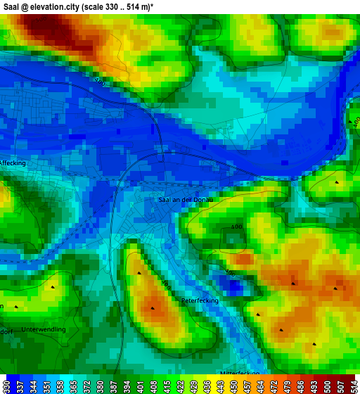
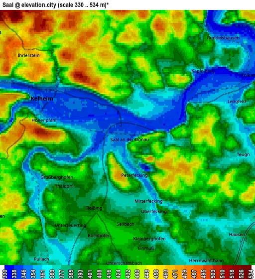
Below is the Elevation map of Saal, which displays elevation range with different colors. Scale of the first map is from 330 to 514 m (1083 to 1686 ft) with average elevation of 389.6 meters (=1278 ft) [note 1]
These maps also provides idea of topography and contour of this city, they are displayed at different zoom levels. More info about maps, scale and edge coordinates you can find below images.
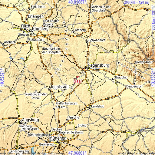
| \ | Map #1 | Map #2 | Topo.Map |
| Scale [m] | 330..514 m | 330..534 m | × |
| Scale [ft] | 1083..1686 ft | 1083..1752 ft | × |
| Average | 389.6 m = 1278 ft | 404.6 m = 1327 ft | × |
| Width | 6.42 km = 4 mi | 12.85 km = 8 mi | 205.6 km = 127.8 mi |
| Height | 6.42 km = 4 mi | 12.85 km = 8 mi | 205.6 km = 127.8 mi |
| ↑Max Latitude | 48.92987° | 48.958733° | 49.81687° |
| Latitude at center | 48.90099° | 48.90099° | 48.90099° |
| ↓Min Latitude | 48.872094° | 48.843181° | 47.96801° |
| ← Min Longitude | 11.888015° | 11.844069° | 10.52571° |
| Longitude center | 11.93196° | 11.93196° | 11.93196° |
| →Max Longitude | 11.975905° | 12.019851° | 13.33821° |
Nearby cities:
Cities around Saal sort by population:
• Kelheim elevation 346 m
3.8 km,  298°
298°
• Abensberg 371 m
11.1 km,  212°
212°
• Bad Abbach 355 m
9.2 km,  63°
63°
• Sinzing 337 m
13.3 km,  33°
33°
• Pentling 410 m
13 km,  45°
45°
• Langquaid 389 m
12.3 km,  134°
134°
• Ihrlerstein 470 m
6 km,  307°
307°
• Painten 507 m
13.5 km,  322°
322°
• Hausen 377 m
7.1 km, 130°
• Teugn 378 m
5.9 km,  98°
98°
• Biburg 371 m
13.4 km,  204°
204°
• Essing 388 m
11 km,  289°
289°
Multilingual:
 En español:
Saal elevación 348 m.
 En France:
Saal élévation 348 m.


Sources and notes:
- [note 1] Map square and city borders are not equal. Map elevation data is calculated only from area inside that square.
- [src 1] Elevation data from geonames database provided with same terms of usage.
- [src 2] The elevation map of Saal is generated using elevation data from NASA's 3 arcsec (90m) resolution SRTM data.
- [src 3] Base (background) map © OpenStreetMap contributors tiles are generated by Geofabrik and OpenTopoMap.
Copyright & License:
This Saal Elevation Map is licensed under CC BY-SA. You may reuse any part from this page, if you give a proper credit by linking to this URL:
 More info on terms of use page.