Biburg elevation
Biburg (Bavaria, Lower Bavaria), Germany elevation is 371 meters and Biburg elevation in feet is 1217 ft above sea level [src 1]. Biburg is a seat of a fourth-order administrative division (feature code) with elevation that is 113 meters (371 ft) bigger than average city elevation in Germany.
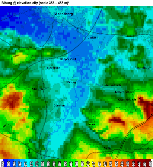
Below is the Elevation map of Biburg, which displays elevation range with different colors. Scale of the first map is from 356 to 455 m (1168 to 1493 ft) with average elevation of 386.8 meters (=1269 ft) [note 1]
These maps also provides idea of topography and contour of this city, they are displayed at different zoom levels. More info about maps, scale and edge coordinates you can find below images.
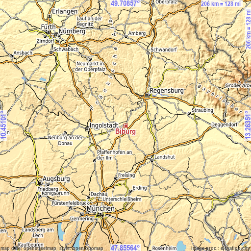
| \ | Map #1 | Topo.Map |
| Scale [m] | 356..455 m | × |
| Scale [ft] | 1168..1493 ft | × |
| Average | 386.8 m = 1269 ft | × |
| Width | 6.44 km = 4 mi | 206 km = 128 mi |
| Height | 6.44 km = 4 mi | 206 km = 128 mi |
| ↑Max Latitude | 48.819603° | 49.70857° |
| Latitude at center | 48.79066° | 48.79066° |
| ↓Min Latitude | 48.7617° | 47.85564° |
| ← Min Longitude | 11.813315° | 10.45101° |
| Longitude center | 11.85726° | 11.85726° |
| →Max Longitude | 11.901205° | 13.26351° |
Nearby cities:
Cities around Biburg sort by population:
• Kelheim elevation 346 m
14.2 km,  8°
8°
• Neustadt an der Donau 354 m
6.7 km,  285°
285°
• Abensberg 371 m
3 km,  349°
349°
• Saal 348 m
13.4 km,  24°
24°
• Langquaid 389 m
14.7 km,  75°
75°
• Siegenburg 393 m
4.1 km,  189°
189°
• Rohr 425 m
8.8 km,  106°
106°
• Münchsmünster 356 m
13 km,  258°
258°
• Elsendorf 402 m
9.9 km,  200°
200°
• Hausen 377 m
13.3 km,  54°
54°
• Train 416 m
6.6 km, 195°
• Wildenberg 414 m
7.4 km,  155°
155°
Multilingual:
 En español:
Biburg elevación 371 m.
 En France:
Biburg élévation 371 m.


Sources and notes:
- [note 1] Map square and city borders are not equal. Map elevation data is calculated only from area inside that square.
- [src 1] Elevation data from geonames database provided with same terms of usage.
- [src 2] The elevation map of Biburg is generated using elevation data from NASA's 3 arcsec (90m) resolution SRTM data.
- [src 3] Base (background) map © OpenStreetMap contributors tiles are generated by Geofabrik and OpenTopoMap.
Copyright & License:
This Biburg Elevation Map is licensed under CC BY-SA. You may reuse any part from this page, if you give a proper credit by linking to this URL:
 More info on terms of use page.